Map, Compass & GPS

Map, Compass & GPS
Wild flowers along Fall Creek on the way to the Green Lakes - Oregon

Monday, June 27, 2011

Trusting Your GPS

Never trust your GPS?

The following is an article from www.news.discovery.com.  The writer is Emily Sohn.

She asks a very interesting question.  Do we trust our technology too much?

"Getting lost in the wilderness can be terrifying, even tragic. It can also be perplexing, as with a recent case in a remote area of Nevada.

A little over a week ago, a woman was rescued on the verge of death after being stranded for nearly two months on muddy back roads in the northeastern part of the state. Her husband, who walked off looking for help, is still missing. The most baffling part of the story: The couple had a GPS device. And they were following its directions when they got lost.

It’s not the first time that blind faith in a GPS has led people astray and into big trouble. And given the growing influence of computer technology on our lives, experts say, it’s not that surprising. As we become ever more reliant on digital devices, the relationship between humankind and the wilderness is rapidly shifting.

Armed with a GPS, in particular, many people ignore notice ridge lines, stream routes and landscape contours, said Bill Borrie, a wilderness researcher at the University of Montana, Missoula. Most also fail to learn critical wilderness survival skills in the first place."

To read the complete article go here.

Saturday, June 25, 2011

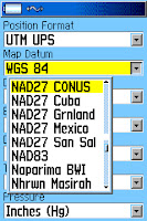
GPS Setup - Map Datum


Getting to the right destination is important to the backcountry traveler.  Setting your GPS to the right Map Datum makes a big difference.  Not selecting the right datum could put you miles away from your intended location!!!!
Datum is a term that GPS users should be aware of.  It is a set-up function and option found on all receivers.

Figure 1 The units page where you can change map datum.


In essence, map datum is a mathematical model used to take information from a spherical earth and adjust that information for placement on a flat map.  Of course we can get much more technical but in reality, that is about all the hiker/hunter needs to know.
It is the application of datum that is important to hikers.
Today, most US Geologic Survey (USGS) topographic (topo) maps are based on a map datum called the North American Datum of 1927; or NAD 27.  This information is found at the bottom left of a topo.

To read the rest of the article go here.

Monday, June 20, 2011

SPOT Rescue

SAR team member Doug McCall has an excellent post regarding the use of the SPOT beacon.  His report follows the rescue of an individual in Washington State.

I have had my SPOT (the original version) going on three years.  It has served me well.

The following is Doug McCall's report found in Backcountry Rescuer Magazine.

Here is his report.

Saturday, June 18, 2011

Lightning

Avoid becoming a lightning casualty.  Wild fires are common in the West.  Many fires are started by lighning.  Though rare, hikers are hit by lightning.


The following is by my friend Peter Kummerfeldt:


About 2,000 people are injured by lightning strikes around the world each year, according to the National Lightning Safety Institute. In the U.S., about 10 percent of those struck die, for an average of 40 to 50 deaths per year. Lightning is the #2 weather killer nationwide, second only to floods. The odds of being struck by lightning during a given year are 1:700,000.


But if you’re one of the unlucky victims, lightning can hurt you in several different ways:


To read the rest of the post go here.

Wednesday, June 15, 2011

Moss On The North Side

Can you really find north or south by looking at a tree?

I bring this up today because this topic has started to pop up in my land navigation classes.

Recently, one of my students told me about a Ray Mears' video on http://www.youtube.com/.  It's called the "Path Finder."  To watch the video go here.  The student asked my my opinion of Mears' methods.

He brings up some interesting topics and demonstrates determining direction;

  1. By looking at the growth of tree limbs (larger limbs on the south side)
  2. Finding a cut tree stump and determining directions based on the growth rings
  3. Using the hour hand of a watch to determine direction, and;
  4. Using the sun, stick and shadow method to determine direction.
I'd comment that numbers 1 & 2 above depends upon your location and latitude.  There are a lot of variables with this method that may or may not work in the Pacific Northwest.

My survival class tested the tree limb theory on the campus of a college in the Willamette Valley of Oregon.  Though there were several deciduous trees, most were fairly young and none convincingly pointed south.

Number 2, I've got to find a tree stump to check that out.  Still, if you are on a north facing slope will you get that clear direction determination? 

So, in my region of the Northwest, method 1 & 2 are not working for me.

Methods 3 & 4 have been illustrated in books for years.  Do they work,  sure.  But I'd ask you to consider just how accurate these methods are.  Rather than a specific heading such as 180 degrees (that is south) you will get a trend of direction; as in you are heading in a southerly direction.  That may be all you need.

It might be hard to test out method 3 with a digital watch.

For more information about methods 3 & 4 take a look at the following references:

  1. Staying Found by June Fleming, Chapter 7
  2. Camping & Wilderness Survival by Paul Tawrell, start on page 175
Remember, no matter what you read or watch on TV - a new method - has to work for you.  Test it out at home.

As an aside, I have enjoyed the few Ray Mears' videos that I have seen.  If you are looking for a good video on backcountry survival in winter watch his BBC documentary, the Real Hero's of Telemark; here.  It's is outstanding.

Update: June 20.  I was able to link up with a friend (who has a doctorate in Forestry.)  His sense was that trying to depend on the growth rings of a tree was risky and depended on too many variables to be of use.


Saturday, June 11, 2011

Lost In The Backcountry

You'll be safe in the backcountry if you carry the right gear and plan ahead.  Preparation is everything!
The hunter sat quietly through my GPS class.  No questions were asked but he was especially attentive and focused.  He was “pinned to my hip” during the night field exercise where we entered GPS waypoints and navigated through town.  The hunter had plenty of questions as we marched along using GPS and compass.
As we wrapped up the field portion the hunter commented, “I guess you’ve heard of me?  I know your Search and Rescue (SAR) team pretty well now.”  He told me about becoming lost during deer season in Oregon’s Three Sisters Wilderness.  After class he went into more detail.  Much to his credit, during the next class session he shared his experience of being lost in the backcountry.
He helped his sister field dress, hang and skin her first mule deer.  No one wanted the deer’s hide so he wrapped it up, mounted his horse and road down several abandoned logging roads to dispose of it. His route twisted through the wilderness.  The hunter found a spot and rested a while.  The lodge pole pine was thick like a thicket.  The horizon was obscured.
Prior to this trip he had built a first aid and survival kit filled with gear.  But today his pack with the GPS, fire starter and shelter remained in camp.  After all, this was a short trip.  The plan was to be back well before twilight.
To read the rest of the post go here.

Thursday, June 9, 2011

Delorme inReach

Delorme Introduces inReach – First 2-Way Consumer SEND

inReachDelorme has announced their long-awaited two-way satellite messaging device, the inReach. Unlike Delorme’s first SEND, which was a SPOT product that utilizes the Globalstar satellite system one-way messaging capability, inReach works on the Iridium system that provides full two-way communication, with obvious benefits.

To read the complete post go here.

Wednesday, June 8, 2011

More Solar Activity

Right now the sun is getting active.  What is the impact? 

The earth has entered into a busy solar cycle. 

On Sunday NASA released a video of the latest solar eruption.  It's pretty spectacular.

So, what is the impact?

As amazing as it is, the government is not anticipating serious damage.  Still, the GPS system and the power grid are being closely monitored.

If there is any impact it will be noticed on Thursday, June 9.

For more information and a very interesting video go here.

Tuesday, June 7, 2011

Seattle Backpacker Magazine

Looking for an online magazine with a focus on backpacking, hiking, SAR and information on the backcountry? 

You need to check this site out.

This online magazine has a ton of info that is just first rate.  It's free.

The articles cover everything from hiking the Pacific Northwest, navigation, stove reviews, health and recommended treks.

You just can't beat it.  To read more go here.

Sunday, June 5, 2011

Stoves

Is a liquid fueled stove better than a gas stove?  Which is the best choice?

I still have my original liquid fuel stove that I bought in Corvallis, Oregon in 1973.  What an improvement that was for a novice backpacker that relied far to heavily on wood as a cooking fuel.  It was heavy but fit nicely in my Kelty's external pocket.

Now I have a small collection of stoves that work well for me.  My alcohol stove is on the shelf until I find a better one.

Hikin_Jim at Adventures in Stoving has a nice post on the pros and cons of liquid vs. gas stoves.

Read his post here.

Wednesday, June 1, 2011

GO or No GO

You are in the backcountry and in a survival situation.  You need to make a decision.  Do you remain in place or "self rescue" and head out.

My friend Peter Kummerfeldt has a great article about what to consider in a survival situation.

"GO – NO GO Decisions

Does anyone know you are missing? If you left a “trip plan” with friends or family members, and you did not deviate from the plan, a search will begin as soon as the trip plan expires and the authorities are notified.  The plan should include, at a minimum, your destination, departure and return dates and times, the names of those traveling with you, the kinds of clothing and equipment carried and the outdoor experience of the party.
If someone knows where you've gone, that will expedite the search!

If someone knows you’re missing you can take heart in the fact that SAR forces will be looking for you.  Your job as the survivor then is twofold: to keep yourself alive until they get there and to expedite your recovery by drawing their attention to your location by signaling.
If you have not left a trip plan and no one knows where you are or when you are supposed to return, making your own way out may be your only choice.  Leaving a trip plan and sticking to that plan is without question, your best option for a quicker rescue."
Read the rest of his post here.
I have posted a suggested hiker/hunter trip plan at my web site www.outdoorquest.biz.
The plan is a simple .pdf file.  A link to the plan is here.
Your feedback is welcome.