www.lifeisbetter.us is a new web that you should visit.
Life
Is Better a new website by and for hiking, backpacking and mountain climbing
enthusiasts. The idea is simple: There are hundreds of quality websites offering
great content and information for hiking, backpacking and mountain climbing but
there is no easy way to see the best of what’s new quickly on a daily basis—we
strive to be the solution. Curated daily by our editors, if there is something
new that we think you would be interested in, we will present it to you.
Discover great articles, interesting videos, informative tips, in depth gear
reviews, and much more. Think of Life Is Better… as your daily curated browse
engine. Check us out at www.lifeisbetter.us/hiking-climbing.
and send us your thoughts to contact@lifeisbetter.us .
Map, Compass & GPS

Wild flowers along Fall Creek on the way to the Green Lakes - Oregon
Tuesday, December 24, 2013
Wednesday, December 11, 2013
Survival Bibliography - Great Books To Read
The following post is from my friend Peter's web site. This is very comprehensive. Looking for a good read on survival - here is your list.
by Peter Kummerfeldt
by Peter Kummerfeldt
This bibliography was assembled by myself and Skip Stoffel, the president of of Emergency Response International. We selected books that we use as sources of information in the development of the many programs that both OutdoorSafe Inc and ERI present nationally and internationally each year. Some of these books are of the “how to survive” variety and others are the “been there, done that, didn’t like but survived” variety. Much can be learned from both genres of books. As with any research no one source should be considered the absolute authority on any given topic. Rather reading the material presented by many authors will result in a broader understanding of what it takes to survive. In the past much of the information presented in many survival training programs was derived from the experiences of the most recent survivor.
To read the rest of Peter's post go here.
Saturday, December 7, 2013
Map Datum
Getting to the right destination is important to the backcountry traveler. Setting your GPS to the right Map Datum makes a big difference. Not selecting the right datum could put you hundreds of yards away from your intended location!!!!
 It is the application of datum that is important to hikers.
Datum is a term that GPS users should be aware of. It is a set-up function and option found on all receivers.
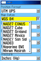

In essence, map datum is a mathematical model used to take information from a spherical earth and adjust that information for placement on a flat map. Of course we can get much more technical but in reality, that is about all the hiker/hunter needs to know.

Today, most US Geologic Survey (USGS) topographic (topo) maps are based on a map datum called the North American Datum of 1927; or NAD 27. This information is found at the bottom left of a topo.
To read the rest of the article go here.
To read the rest of the article go here.
Can a Three Season Tent Be Used In The Winter.
The following is from Philip Werner's www.sectionhiker.com . A very timely topic. Do read the comments to his post, lots of good discussion there.
A winter trip participant asked me recently if it was OK for them to bring a three-season tent on a winter backpacking trip in the White Mountains.
Here’s how I replied:
Read the rest of Philip's post here.
A winter trip participant asked me recently if it was OK for them to bring a three-season tent on a winter backpacking trip in the White Mountains.
Here’s how I replied:
Read the rest of Philip's post here.
Thursday, December 5, 2013
Selecting a Magnetic Compass
What should you look for when you pruchase a magnetic compass?
 It is just common sense.
You need a good compass to match your needs.
So what works and what is acceptable for the average hiker?
Regretably, most retail sales staff just don't have a clue.
You can by a decent magnetic compass for under $20. You can buy a crummy compass for under $10. So it is not a hard choice.
 I recommend a baseplate compass like the one above (Silva Ranger - $50.) or the Burnton 8010G (green baseplate on right; under $20).
Importantly, each can be adjusted for declination.
For more information check here.

You need a good compass to match your needs.
So what works and what is acceptable for the average hiker?
Regretably, most retail sales staff just don't have a clue.
You can by a decent magnetic compass for under $20. You can buy a crummy compass for under $10. So it is not a hard choice.

Importantly, each can be adjusted for declination.
For more information check here.
Wednesday, December 4, 2013
Cold Water Survival
The following is from my friend Leon's site www.survivalcommonsense.com. Make sure to watch the video.
If you fall into icy water or through the ice on a winter ski or snowshoe trip, you are immediately in serious trouble. How do you get out after you’ve fallen in? Here’s some advice and information from an expert.

My faceplant was inelegant, a complete surprise and the shock of going into the water caused an involuntary gasp. When I emerged, sputtering, my hunting buddies all cheered.
But first things first: How exactly do you get out of a hole in the ice? Is there a best technique for getting back onto solid ice? And how long can you last immersed in ice water?
To read the rest of Leon's post go here.
If you fall into icy water or through the ice on a winter ski or snowshoe trip, you are immediately in serious trouble. How do you get out after you’ve fallen in? Here’s some advice and information from an expert.
by Leon Pantenburg
The Sunflower Recreation Area Greentree Reservoir edge was rimmed with ice, and I was waist deep in it, wader hunting for ducks about 40 miles north of Vicksburg, MS. I set up a couple decoys in a little clearing, leaned against a cypress tree, and was sounding a feeding call. A flight of ducks came whistling through the trees, so I moved forward…and tripped over a log.My faceplant was inelegant, a complete surprise and the shock of going into the water caused an involuntary gasp. When I emerged, sputtering, my hunting buddies all cheered.
But first things first: How exactly do you get out of a hole in the ice? Is there a best technique for getting back onto solid ice? And how long can you last immersed in ice water?
To read the rest of Leon's post go here.
Tuesday, December 3, 2013
Evaluating a Back-up Compass
Should you carry a back-up compass in your pack? What kind of compass should you consider?
I wrote the following post in August 2012 for www.seattlebackpackersmagazine.com.
In my backcountry land navigation class, I am frequently asked about the need to carry a back-up compass. Students are generally interested in a lightweight model that is low in cost, small in size, and would “fill in” as needed.
I purposefully evaluated several models that many consider to be back-up options. When choosing a back-up magnetic compass, the hiker must ask himself, “What are my priorities? Accuracy? Reliability? Cost? Size and weight?”
To read the rest of the post go here.
Monday, December 2, 2013
GPS Setup - North or Magnetic North
Should you use true north or magnetic north when you setup your GPS receiver?
I keep my navigation simple and choose true north.

Much of land navigation is based on the relationship to the North Pole; also known as “true north. The measure of degrees of direction in relation to true north is called “degrees true.” Maps are laid out in degrees true. Land features (buttes, mountains, streams) on a topographic map are in reference to degrees true. By that I mean the bearing from one mountain peak to another will be referenced in degrees true.
The issue is that the magnetic compass’s direction information is in degrees magnetic. The angular measurement between degrees true and degrees magnetic is called declination. The hiker will need to compensate for declination.
In the Navy I learned to keep my navigation simple.

In the Navy during a bridge watch, I evaluated the ship’s position on a navigation chart. The principle navigation compass (a gyro repeater) reported in degrees true; the backup compass reported in degrees magnetic. Key to this navigation was the both the principle navigation compass and chart used degrees true.