The
day started clear and bright as the hikers left the trailhead near Newport,
Oregon. The temperatures were to be moderate most of the day with slight
cooling in the evening. They pressed on determined to reach the summit before
twilight. After reaching the summit at dusk, the group started to make their
way back to the trailhead as fog began to roll in. Within an hour the darkness
was becoming a problem and the safety of continued travel became
questionable.
So
what are some basic considerations for night time travel and navigation in the
backcountry?
First,
let us consider that we are not in a “lost hiker” scenario. If lost, the best
thing to do is to just stay where you are. This makes the job much easier for
the searchers.
Further,
recommendations are based on the concerns and issues of hiking when it is really
dark, not during the period of a full moon with some ambient light.
To read the rest of the post go here. |
Map, Compass & GPS

Wild flowers along Fall Creek on the way to the Green Lakes - Oregon
Sunday, April 29, 2012
Night Travel and Navigation
Monday, April 23, 2012
Earthquakes
The Casscadia Subduction Zone is getting a lot of attention. Here is an article from Discover Magazine's Jerry Thompson about the concerns of this zone for Northern California, Oregon, and Washington.
The Giant, Underestimated Earthquake Threat to North America
Now scientists are calling attention to a dangerous area on the opposite side of the Ring of Fire, the Cascadia Subduction Zone, a fault that runs parallel to the Pacific coast of North America, from northern California to Vancouver Island. This tectonic time bomb is alarmingly similar to Tohoku, capable of generating a megathrust earthquake at or above magnitude 9, and about as close to Portland, Seattle, and Vancouver as the Tohoku fault is to Japan’s coast. Decades of geological sleuthing recently established that although it appears quiet, this fault has ripped open again and again, sending vast earthquakes throughout the Pacific Northwest and tsunamis that reach across the Pacific.
To read the complete article go here.
The Giant, Underestimated Earthquake Threat to North America
The enormous fault off
the coast of the Pacific Northwest has been silent for three centuries. But after years of detective work, geologists have
discovered that it can
unleash mayhem on
an epic scale.
Now scientists are calling attention to a dangerous area on the opposite side of the Ring of Fire, the Cascadia Subduction Zone, a fault that runs parallel to the Pacific coast of North America, from northern California to Vancouver Island. This tectonic time bomb is alarmingly similar to Tohoku, capable of generating a megathrust earthquake at or above magnitude 9, and about as close to Portland, Seattle, and Vancouver as the Tohoku fault is to Japan’s coast. Decades of geological sleuthing recently established that although it appears quiet, this fault has ripped open again and again, sending vast earthquakes throughout the Pacific Northwest and tsunamis that reach across the Pacific.
To read the complete article go here.
Saturday, April 21, 2012
Using a Compass
Check out Brian Greens post about using a compass.
Using a Compass - The Basics
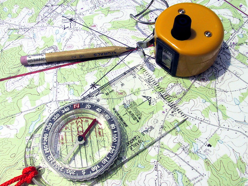
I quite often run into fellow backpackers during my hikes and enjoy chatting with them about where they're from and what they're doing, the usual trail chit-chat. A lot of the time our conversations include discussions about the current hike and conditions along the trail, where to find water and areas to avoid if necessary, sharing information with fellow hikers is one of the best parts of meeting people along the trail, in my opinion.
However, on more than one recent occasion (too often, in fact) the conversation has included the seemingly innocent question of "so, where are we on the trail - any idea?" To which I am always shocked and usually ask, "don't you carry a map and a compass?" This elicits several knee-jerk responses, the most frequent being, "yes, but I'm not exactly sure how to use the compass," along with a sheepish grin. Inside my head I'm thinking, "then why are you carrying it and how on earth do you navigate your position?"
To read the rest of Brian's post go here.
Using a Compass - The Basics
I quite often run into fellow backpackers during my hikes and enjoy chatting with them about where they're from and what they're doing, the usual trail chit-chat. A lot of the time our conversations include discussions about the current hike and conditions along the trail, where to find water and areas to avoid if necessary, sharing information with fellow hikers is one of the best parts of meeting people along the trail, in my opinion.
However, on more than one recent occasion (too often, in fact) the conversation has included the seemingly innocent question of "so, where are we on the trail - any idea?" To which I am always shocked and usually ask, "don't you carry a map and a compass?" This elicits several knee-jerk responses, the most frequent being, "yes, but I'm not exactly sure how to use the compass," along with a sheepish grin. Inside my head I'm thinking, "then why are you carrying it and how on earth do you navigate your position?"
Wednesday, April 18, 2012
Working With Degrees
Keeping my navigation simple is my goal. Backcountry navigators have the option to set their compass to work in degrees magnetic (in relation to magnetic north) or degrees true (in relation to the North Pole.) I find that working in degrees true is simple and straight forward.


I spent many long hours on the bridge of destroyers while serving at sea in the Navy. At the start of a bridge watch I carefully checked the navigation picture with a solid review of the chart (a mariners map), the compass, celestial observations reported and electronic navigation systems.
Compass and directional data presented to me was in degrees true.
It was natural then, to apply degrees true to my backcountry navigation. It’s just so simple.

A hiker’s magnetic compass provides direction in terms of degrees measured from the earth’s magnetic north pole. The red magnetic needles swings and points to magnetic north.

Declination must be accounted for with any magnetic compass. Declination is the distortion of the earth’s magnetic field caused by the movement of molten metals deep inside the earth. (For more information, read my post on declination HERE.)
When working with map and compass the angular measurement of declination will either be added or subtracted to arrive at a true bearing. Calculation is necessary because a topographic map is oriented to degrees true; compass and map must match.
I found this process to be cumbersome.
Long ago I swapped out my basic compass for one that can be adjusted for declination. The compass needle still points to magnetic north but the dial on the rotating compass housing provides data in degrees true; it has been adjusted. I can pre-set the declination adjustment at home before starting my trip. I can find the declination information at the bottom of my USGS map, or, if the map is old, I’ll visit www.magnetic-declination.com to get the current value.
Now my compass is matched to the map.

The next step is to align the Global Positioning receiver (GPS) to match the map and compass. I’ll due this via the “set up” menu.
Now all my navigation equipment matches.
Saturday, April 7, 2012
Death of a Cougar

The following is an excerpt of an article by Gary Lewis from the March 8, 2012 "Bend Bulletin."
Before there is new life, there must be death. In February, the deer and elk cast off their old crowns. Even as yesterday’s antlers fall away, new growth begins at the pedicle.
It was a Sunday afternoon and the weather forecast called for wind on the high desert. Brian Davis of Redmond calculated he had a few hours to look for antlers on public land between Bend and Sisters. He parked his car a little way off the road and felt the wind in his face as he walked up through the junipers and pines.
When the sun was high in the sky, he topped out on a knob and caught a glimpse of movement up ahead. A tawny body. Dappled sun on muscled flanks.
“I looked through the buckbrush and saw this big brown animal running. It had a long, black-tipped tail. He definitely saw me first,” Davis said. “It was 50 yards away. I walked right onto it.”
Brian whipped out his camera to try to get a picture and trotted up through the brush for a better look.

Brian has taken many photos of the site and has tastefully
framed the results of the cat encounter.


For more information Brian may be contacted by phone at 541-350-3180
Why Hikers and Hunters Get Lost

The following is an article from Backpackers Magazine by Kelly Bastone.

Like a pencil-chewing stats geek from the world of fantasy baseball, survival guru Robert Koester knows his numbers. Really knows his numbers. Lost-hiker incidents in 2003? Check. Climbing accidents in 2006? Check. Heart attacks,
sprained ankles, falls, and bear attacks that resulted in wilderness rescues? He knows them all. That's because Koester, a 45-year-old from Charlottesville, Virginia, has spent the past seven years creating the International Search and
Rescue Database. With 50,000 documented incidents, it's the largest, and first,
compendium of its kind in the world. But the lifelong hiker isn't just a collector; like
a backcountry actuary, he also analyzes risk. Using his vast database, Koester
predicts who will live, who will die, and, most importantly, where lost hikers may
be found.
To read the rest of the article about Robert Kester go here.
Sunday, April 1, 2012
Book Review by Kummerfeldt
Here is the review of another book on backcountry survival. Kummerfeldt cuts to the chase quickly in this review.
By Peter Kummerfeldt.
 I’m a sucker for a new how-to-survive book and can’t resist the urge to buy it when I see one that isn’t already in my library. So when I came across “Show Me How to Survive” by Joseph Pred and the editors of OutdoorLife magazine I ordered it in hopes that maybe, just maybe, there might be something worthwhile in it. My hopes were dashed yesterday when the book arrived in the mail.
To read the rest of the book review go here.