www.lifeisbetter.us is a new web that you should visit.
Life
Is Better a new website by and for hiking, backpacking and mountain climbing
enthusiasts. The idea is simple: There are hundreds of quality websites offering
great content and information for hiking, backpacking and mountain climbing but
there is no easy way to see the best of what’s new quickly on a daily basis—we
strive to be the solution. Curated daily by our editors, if there is something
new that we think you would be interested in, we will present it to you.
Discover great articles, interesting videos, informative tips, in depth gear
reviews, and much more. Think of Life Is Better… as your daily curated browse
engine. Check us out at www.lifeisbetter.us/hiking-climbing.
and send us your thoughts to contact@lifeisbetter.us .
Map, Compass & GPS

Wild flowers along Fall Creek on the way to the Green Lakes - Oregon
Tuesday, December 24, 2013
Wednesday, December 11, 2013
Survival Bibliography - Great Books To Read
The following post is from my friend Peter's web site. This is very comprehensive. Looking for a good read on survival - here is your list.
by Peter Kummerfeldt
by Peter Kummerfeldt
This bibliography was assembled by myself and Skip Stoffel, the president of of Emergency Response International. We selected books that we use as sources of information in the development of the many programs that both OutdoorSafe Inc and ERI present nationally and internationally each year. Some of these books are of the “how to survive” variety and others are the “been there, done that, didn’t like but survived” variety. Much can be learned from both genres of books. As with any research no one source should be considered the absolute authority on any given topic. Rather reading the material presented by many authors will result in a broader understanding of what it takes to survive. In the past much of the information presented in many survival training programs was derived from the experiences of the most recent survivor.
To read the rest of Peter's post go here.
Saturday, December 7, 2013
Map Datum
Getting to the right destination is important to the backcountry traveler. Setting your GPS to the right Map Datum makes a big difference. Not selecting the right datum could put you hundreds of yards away from your intended location!!!!
 It is the application of datum that is important to hikers.
Datum is a term that GPS users should be aware of. It is a set-up function and option found on all receivers.
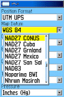

In essence, map datum is a mathematical model used to take information from a spherical earth and adjust that information for placement on a flat map. Of course we can get much more technical but in reality, that is about all the hiker/hunter needs to know.

Today, most US Geologic Survey (USGS) topographic (topo) maps are based on a map datum called the North American Datum of 1927; or NAD 27. This information is found at the bottom left of a topo.
To read the rest of the article go here.
To read the rest of the article go here.
Can a Three Season Tent Be Used In The Winter.
The following is from Philip Werner's www.sectionhiker.com . A very timely topic. Do read the comments to his post, lots of good discussion there.
A winter trip participant asked me recently if it was OK for them to bring a three-season tent on a winter backpacking trip in the White Mountains.
Here’s how I replied:
Read the rest of Philip's post here.
A winter trip participant asked me recently if it was OK for them to bring a three-season tent on a winter backpacking trip in the White Mountains.
Here’s how I replied:
Read the rest of Philip's post here.
Thursday, December 5, 2013
Selecting a Magnetic Compass
What should you look for when you pruchase a magnetic compass?
 It is just common sense.
You need a good compass to match your needs.
So what works and what is acceptable for the average hiker?
Regretably, most retail sales staff just don't have a clue.
You can by a decent magnetic compass for under $20. You can buy a crummy compass for under $10. So it is not a hard choice.
 I recommend a baseplate compass like the one above (Silva Ranger - $50.) or the Burnton 8010G (green baseplate on right; under $20).
Importantly, each can be adjusted for declination.
For more information check here.

You need a good compass to match your needs.
So what works and what is acceptable for the average hiker?
Regretably, most retail sales staff just don't have a clue.
You can by a decent magnetic compass for under $20. You can buy a crummy compass for under $10. So it is not a hard choice.

Importantly, each can be adjusted for declination.
For more information check here.
Wednesday, December 4, 2013
Cold Water Survival
The following is from my friend Leon's site www.survivalcommonsense.com. Make sure to watch the video.
If you fall into icy water or through the ice on a winter ski or snowshoe trip, you are immediately in serious trouble. How do you get out after you’ve fallen in? Here’s some advice and information from an expert.

My faceplant was inelegant, a complete surprise and the shock of going into the water caused an involuntary gasp. When I emerged, sputtering, my hunting buddies all cheered.
But first things first: How exactly do you get out of a hole in the ice? Is there a best technique for getting back onto solid ice? And how long can you last immersed in ice water?
To read the rest of Leon's post go here.
If you fall into icy water or through the ice on a winter ski or snowshoe trip, you are immediately in serious trouble. How do you get out after you’ve fallen in? Here’s some advice and information from an expert.
by Leon Pantenburg
The Sunflower Recreation Area Greentree Reservoir edge was rimmed with ice, and I was waist deep in it, wader hunting for ducks about 40 miles north of Vicksburg, MS. I set up a couple decoys in a little clearing, leaned against a cypress tree, and was sounding a feeding call. A flight of ducks came whistling through the trees, so I moved forward…and tripped over a log.My faceplant was inelegant, a complete surprise and the shock of going into the water caused an involuntary gasp. When I emerged, sputtering, my hunting buddies all cheered.
But first things first: How exactly do you get out of a hole in the ice? Is there a best technique for getting back onto solid ice? And how long can you last immersed in ice water?
To read the rest of Leon's post go here.
Tuesday, December 3, 2013
Evaluating a Back-up Compass
Should you carry a back-up compass in your pack? What kind of compass should you consider?
I wrote the following post in August 2012 for www.seattlebackpackersmagazine.com.
In my backcountry land navigation class, I am frequently asked about the need to carry a back-up compass. Students are generally interested in a lightweight model that is low in cost, small in size, and would “fill in” as needed.
I purposefully evaluated several models that many consider to be back-up options. When choosing a back-up magnetic compass, the hiker must ask himself, “What are my priorities? Accuracy? Reliability? Cost? Size and weight?”
To read the rest of the post go here.
Monday, December 2, 2013
GPS Setup - North or Magnetic North
Should you use true north or magnetic north when you setup your GPS receiver?
I keep my navigation simple and choose true north.

Much of land navigation is based on the relationship to the North Pole; also known as “true north. The measure of degrees of direction in relation to true north is called “degrees true.” Maps are laid out in degrees true. Land features (buttes, mountains, streams) on a topographic map are in reference to degrees true. By that I mean the bearing from one mountain peak to another will be referenced in degrees true.
The issue is that the magnetic compass’s direction information is in degrees magnetic. The angular measurement between degrees true and degrees magnetic is called declination. The hiker will need to compensate for declination.
In the Navy I learned to keep my navigation simple.

In the Navy during a bridge watch, I evaluated the ship’s position on a navigation chart. The principle navigation compass (a gyro repeater) reported in degrees true; the backup compass reported in degrees magnetic. Key to this navigation was the both the principle navigation compass and chart used degrees true.
Wednesday, November 27, 2013
Emergency Shelters
By Peter Kummerfeldt
Based on what we read there should always be a convenient hollow tree, rocky overhang or cave a person in trouble could use for shelter. It’s strange how when you are not in trouble any number of suitable shelters can be found but when you really need one – they are in short supply. Murphy’s Law I guess!
I have always believed that if you are going to need a shelter you had better have the materials with you to build it! I also believe that it is impossible for the typical survivor to build a waterproof, wind proof shelter from natural materials!
To read the rest of the post go here.
GPS Set-up - Using the Right Coordinates

Well
maybe not.
A GPS is a very versatile backcountry computer and
satellite receiver. Today’s receiver can
be taken anywhere around the world and when setup properly will provide
accurate position information. Coordinate
information can be uploaded/downloaded to a PC and edited. It is the setup process
that our fisherman needs to be aware of.
To read the complete post go here.
Thursday, November 21, 2013
Signalling Your Rescuers
When you are lost in the backcountry it is essential that the hiker be able to signal to the searchers. There are many ways to do this. Consider a signal mirror. They are compact and their flash (reflection) can be seen from a long distance.
Check out Peter Kummerfeldt's short video on signalling with a mirror here.
Check out Peter Kummerfeldt's short video on signalling with a mirror here.
Wednesday, November 20, 2013
The Myths Surrounding Search and Rescue
This is such a timely piece about Search and Rescue that I thought it time to post it again. The site listed below is top notch and full of wonderful posts/articles.
This is a fine article from http://seattlebackpackersmagazine.com/ about the myths associated with Search and Rescue teams.
by Erika Klimecky
So now you know who they are. They are the people that the news stations refer to when “a search is underway”. They are the teams that roll out of bed at all hours and go out into the back-country to find missing or lost people. They find evidence, follow tracks and bring people out of the wilderness and back to safety. But there is still a lot of confusion and questions about how Search and Rescue operates. So let’s straighten that out a bit.
Let’s debunk some myths about search and rescue.
To read the rest of the post go to here.
Tuesday, November 19, 2013
Your Escape Route
When hiking in the backcountry do you plan an escape route? It could be invaluable.
I wrote this post in the fall of 2012 during a particularly nasty forest fire.
It was a time of extreme dry weather and the forest was a tinderbox waiting to ignite.
This fire was first observed about 6:30 AM by residents of a small town near the actual fire. Sadly, this information was not relayed to the agency responsible for fighting the fire. By around 11:00AM teams were being dispatched to the scene and assets were being organized.
There were several groups in the backcountry. Going back to their originating trail head was not an option, they needed to escape.

For the last several days I have been working with my Search and Rescue (SAR) team on a forest fire in the Pacific Northwest. The team has helped to coordinate the potential evacuation of a small community and has worked with Forest Service staff to assist stranded hikers. Getting these hikers out safely has been a priority.
To read the rest of the post go here.
Monday, November 18, 2013
REI's Early Sale
REI is now selling the Garmin 62S for $199. Great price. The 62S was $350 when I bought mine last summer.
This is a fine GPS.
View the REI's web page here.
This is a fine GPS.
View the REI's web page here.
Sunday, November 17, 2013
Customizing Your GPS
The following post is by my friend and fellow SAR team member Dan about setting up your GPS.
Like most consumer electronics nowadays, GPS Receivers
(commonly just referred to as “GPS”) come out of the box with many more
features than the average (or even “above-average”) user will ever
need/want/use. The good news is that with a bit of patience, most GPS units can
be customized to simplify the display of information, make the interface more
user-friendly and optimize the use of your device. In this post, we’ll explore
how to accomplish these goals and discuss what this means for your experience
when in the field.
The Garmin eTrex series (10, 20, and 30) is one of the most
popular GPS units for backcountry navigation due to its (relatively) low price,
small size and reliable performance. The examples in this post are all from a
Garmin eTrex 30, so for those of you non-eTrex users (or non-Garmin users), you
may be wondering if you should bother to read on…the answer is “YES!” Although
the screen captures and instructions here will only cover eTrex options, almost
all GPS units allow for some kind of user customization. So even though your
display, menus, etc. may not be exactly the same as what’s presented here, most
of the ideas and concepts should be transferable to your GPS. Additionally,
this will be a great way for you to familiarize yourself with your GPS
interface and the various options supported by your device’s software.
To view Dan's complete post go here.
To view Dan's complete post go here.
Friday, November 15, 2013
The 20 Most Essential Trail Skills
Dave Collins of Clever Hiker as an excellent artilcle on the 20 most essential trail skils for the hiker. I look forward to his videos.
A few months ago, I was trying to determine a focus for the next CleverHiker video series. For our second season, I wanted get away from gear and focus on teaching skills. The idea came about to make a 10-episode series on the most critical trail skills and I started to scribble down ideas.
It didn’t take long to realize that there were far too many critical skills to cram into a single series. So, instead of filming one full series, I decided to film two. I’m calling the two-part series Essential Trail Skills I & II and I’m excited to hear your thoughts. The series will be 20 HD instructional videos to teach the most important trail skills for backpackers of all levels and it’s set to launch in early 2014.
To read the rest of the post visit sectionhiker.com here.
Check out Dave Collins' web site at www.cleverhiker.com
Thursday, November 14, 2013
It Has To Work For You
During the course of teaching GPS classes for
over 12 years and now wilderness survival I have become attached (so to speak)
to a phrase, "It has to work for you."
There is nothing magic here. Nothing novel. Nothing original.
There is nothing magic here. Nothing novel. Nothing original.
People enjoy talking about new technology, equipment or skills that they have learned. They are justifiably proud of their new knowledge.
A good friend got me very interested in using an alcohol stove while backpacking. It is economical, takes up little space and weighs but a few ounces. The problem is, that I can't get mine going reliably. I need more time with it to learn the basics; how simple can that be. But still, it is not working for me.
In SAR training two years ago, one team member told me how a computer mouse pad is great as a stove platform, in the snow while winter camping. So I try it out. I accidentally spill come Coleman white gas fuel on the pad. When I light the stove, of course the pad catches on fire; just great. The spot fire on the pad quickly burned out and just singed the top surface of the pad other wise it was just fine. This works for me.
There are a lot of books out there on backcountry travel and survival. Survival has become very popular. I suggest reading these with a critical eye. If there is a particular technique or skill set that you want to adopt, test it at home first. Though the author may be on the speaking/sportsman show circuit, has his own cable show or is repeatedly on network news be critical. Remember, when you are in a jam, you are responsible for you.
Become cautious when reading old and dated material. For example, in the late 1960's I was give a copy of Colin Fletcher's book, "The Complete Walker." This book got me hooked on backpacking. That said, the book is based on lessons and experiences from almost fifty years ago. Doing some research and review of current methodology may be best.
Interestingly, I am hearing from my students more often, "I heard this was used by the Special Forces," or "I read in a magazine that this is what Special Forces do." Well, OK, but is that really true or better yet, is that important for your needs. It gets down to research and experience.
Let's consider land navigation. It is a practiced yet
perishable skill. You need to be on your game. If you are the team
navigator, you skill and techniques have to work for everyone.
So my point would be, as you prepare for a trip or hike, as you put new gear into your pack, test it in advance. Make sure it works for you.
So my point would be, as you prepare for a trip or hike, as you put new gear into your pack, test it in advance. Make sure it works for you.
Wednesday, November 13, 2013
The following is by Peter Kummerfeldt. I check his web site and blog routinely.
by Peter Kummerfeldt
The single most important step in getting rescued quickly is to leave a trip plan with two reliable people you can count on to raise the alarm when you don’t show up on time. It follows, then, that having left a trip plan you abide by it and if you deviate from the plan, inform those with whom you left the original plan.
Include in the Plan:
To read the rest of Peter's post go here.
Friday, November 8, 2013
About Google Earth
Here is another website to check out. I keep my eye on www.gpstraining.co.uk
This is a site that is serious about land navigation and GPS in particular. I subscribe to their newsletter - great info.
Here is a sample from Peter at their site. This came in their latest newsletter.
He has a info sheet on using Google Earth too.
This is a site that is serious about land navigation and GPS in particular. I subscribe to their newsletter - great info.
Here is a sample from Peter at their site. This came in their latest newsletter.
He has a info sheet on using Google Earth too.
| About Google Earth |
|
|
|
|
|
|
Wednesday, November 6, 2013
Topographic Map Contour Lines
Ever wonder how to read a topographic map? Here’s how to fully understand contour maps.
Contours are the thin brown lines that snake across a topographic (topo) map. Contour lines connect equal points of elevation such that every point on a specific line will be at that same elevation above sea level.

To read the rest of this post visit SeattleBackPackersMagazine.com and go here.
Read my other post on topographic lines here.
Read my other post on topographic lines here.
Monday, November 4, 2013
Android-based Garmin Monterra
Is an Android-based Garmin GPS Monterra in your future?
Garmin's Monterra is a new receiver being reviewed right now.
Read a review here.
Garmin's Monterra is a new receiver being reviewed right now.
Read a review here.
Topographic Maps For the Hiker
Do you need some help with using a topographic map? Do topographic maps make sense?
There are lots of references to help the hiker use a topographic maps.
 Sometimes there is nothing better than using a quality power point presentation.
There are two that I recommend taking a look at.
www.landnavigation.org is a comprehensive site dedicated to map and compass training.
A site at the World of Teaching presents a good introduction to topographic maps. Go here to their web site.
There are lots of references to help the hiker use a topographic maps.

There are two that I recommend taking a look at.
www.landnavigation.org is a comprehensive site dedicated to map and compass training.
A site at the World of Teaching presents a good introduction to topographic maps. Go here to their web site.
Thursday, October 31, 2013
GPS Setup - Calibrating The Electronic Compass

Recently I held a GPS navigation seminar at a
At one point during the seminar one man described the inaccuracy of his GPS and asked what he could do about it. He was frustrated that on several occasions while returning to camp the GPS compass arrow (while in the “Find,” “Where to” mode) was providing unreliable information. He’d arrive in camp and the receiver would direct him in a new direction and distance.
As he related his story, I noticed that several other attendees nodded in agreement that they too had the same problem. I asked the fellow if he had ever calibrated the electronic compass. “Yes, when I first got the GPS,” was his reply.

When I explained that the electronic compass should be calibrated after EVERY battery change, the group’s response was one of surprise.
To read the complete article go here.
Tips for Hiking During the Hunting Season
Recommendations for a safe hike.
The following post is by Rebecca Walsh at www.seattlebackpackersmagazine.com. Good info.
"Just because it’s autumn doesn’t mean that hiking season is over. In fact in many parts of the United States hiking is at its best once the temperature drops and the leaves change color.
However, in most parts of the United States hiking during the fall also means sharing the wilderness with hunters. Here are a few tips for hiking safely during hunting season."
To read the rest of the post go here:
I will add to Rebecca's recommendations that it is extremely important to file a trip plan to be left with a responsible person. For more information on a trip plan review my post here.
Sunday, October 27, 2013
Dead Reckoning - An Important Navigation Tool
It is time to return to base camp. Navigation during this trip has been by map and compass alone; no GPS. During the three days of the outing, navigation was straightforward and simple. Visibility was excellent and compass triangulation worked well. Now as the return trip is about to begin, fog has rolled in, masking terrain features. The absence of a reliable trail system will make the return trip challenging as well; travel will be overland.
A process called Dead Reckoning (DR) can be used to navigate and partially compensate for the loss of terrain features and important visual cues. DR is a method used to determine one’s estimated present and future position. Dead Reckoning can be done during periods of darkness, bad weather, in featureless terrain (e.g., the desert, whiteout conditions) or equipment failure (e.g., dead GPS batteries.)
To read the complete post go here.
Friday, October 25, 2013
Choosing a Wilderness Survival School
How do you pick and choose a survival school or an instructor that is right for you?
During my wilderness survival classes I am frequently asked about finding a multi day,
 hands on and rigorous survival course of instruction.
There are a few schools in the Pacific Northwest that cover backcountry survival, GPS navigation and primitive sustainability. Generally I direct folks to Peter Kummerfeldt's summer program because I know that his instruction is first rate and based on years of experience; visit www.outdoorsafe.com.
I frequently visit the web site www.equipped.org. There is a thread running now that discusses vetting a survival instructor. One response was by Bruce Zawalsky who is the Chief Instructor at the Boreal Wilderness Institute. The institute can be visited through their web site www.boreal.net.
Bruce has several thoughtful articles posted on the site that outlines how to become a survival instructor (instructor), instructor development (development) and choosing an instructor (credible).
I also learned of a web site that lists many survival schools throughout the US; schools.
During my wilderness survival classes I am frequently asked about finding a multi day,

There are a few schools in the Pacific Northwest that cover backcountry survival, GPS navigation and primitive sustainability. Generally I direct folks to Peter Kummerfeldt's summer program because I know that his instruction is first rate and based on years of experience; visit www.outdoorsafe.com.
I frequently visit the web site www.equipped.org. There is a thread running now that discusses vetting a survival instructor. One response was by Bruce Zawalsky who is the Chief Instructor at the Boreal Wilderness Institute. The institute can be visited through their web site www.boreal.net.
Bruce has several thoughtful articles posted on the site that outlines how to become a survival instructor (instructor), instructor development (development) and choosing an instructor (credible).
I also learned of a web site that lists many survival schools throughout the US; schools.
Monday, October 21, 2013
First Aid Kit for the Trail
What kind of first aid kit do you carry? Is your kit complete?
The following post is by Erika K at www.seattlebackpackersmagazine.com. Erika is an accomplished long distance hiker in her own right.
"What’s in your first aid kit? It might vary based on your health, your concerns and your hiking location."
"Your kit might look nothing like mine. You might be prepared for things that I am not and vice versa. The group of things here are meant to make you think about trail emergencies and the items you might use to handle them. Some people are comfortable sewing up a gaping wound with used fishing line and a fish hook. Others might lose their cookies at the sight of blood. Whatever you decide to pack, pay attention the terrain you will be travelling in, the weather, and how near (or far) you will be from help, should you need it. If you are out overnight and slice yourself open so you can’t walk, it may be 24 hours or more before Search and Rescue can get to you. These are merely suggestions."
The following is what my SAR team requires as a minimum; go here.
A good first aid kit complements the "ten essentials."
Friday, October 18, 2013
Bushwacking
Philip Werner over at www.sectionhiker.com has a fine post about bushwacking in the backcountry of New England. There are several points that we can all learn from Philip's post.
"I am feeling sore all over today. I’m surprised because our bushwhack over to Southwest Twin Mountain turned out to be easier than we expected. Still bushwhacking is much more strenuous than regular trail hiking and we had a long hike out which must explain it." From Philip Werner's post.
To read his complete post go here.
Mini Survival Kits
What good is a mini survival kit? Five things they can’t do.
Mini, pocket sized survival kits are in every outdoors store. But, really, what good are they?
Mini, pocket sized survival kits are in every outdoors store. But, really, what good are they?
by Leon Pantenburg
Several years ago, the editor at the newspaper I worked at tasked me to write a practical winter survival guide for Central Oregon. It was an investigative reporting assignment, and I interviewed local experts from the Deschutes
County Search and Rescue, as well as local survival equipment tester, the late Jim Grenfell, and internationally-known survival expert Peter Kummerfeldt.
The end result of months of research and testing was a system that included a personal, pocket-sized kit as well as a complete backpack setup for hardcore winter survival. (No survival kit system is perfect, and no kit will work for everyone. View any system as a baseline for developing a kit that will work for you.)
The pocket-sized kit, which was designed to fit into an Altoids tin, drew some fire from the local “survival guru” due in part to his not reading the entire story and the warnings.
To read the rest of this post, visit Leon's web site here.
Wednesday, October 16, 2013
Why Humans Get Lost
Tia Ghose is a Live Science staff writer who
authored an interesting article (March 2013)
 titled Why Humans Get Lost. Through interviews and case studies she
evaluates what causes hikers to get lost in the backcountry. She identifies that in some case carelessness
is a contributor as is our loss of the natural ways of navigating by the stars
and sun. At one point in a section of
the article called “Use it or Lose IT” she states:
titled Why Humans Get Lost. Through interviews and case studies she
evaluates what causes hikers to get lost in the backcountry. She identifies that in some case carelessness
is a contributor as is our loss of the natural ways of navigating by the stars
and sun. At one point in a section of
the article called “Use it or Lose IT” she states:

“But
the sense of direction may also wither with disuse. Small studies have found
that using a GPS for just a few hours seems to impair people's navigational
skills in the short term, …many people get lost because they simply aren't
paying attention….”
In navigation classes and
seminars I frequently comment that navigation is a perishable skill. It is a skill that requires practice and
thought. Navigation skills are not
instinctive but are learned and developed.
Today, the principle components of backcountry navigation
consist of:
1. A
declination adjustable magnetic compass
2. A
quality map
3. A
GPS receiver
Your grandfather’s compass was a wonderful tool in its
day but should be replaced by a declination adjustable compass. Such a compass eliminates the guess work
associated with calculating for declination.
Viable compasses are made by Brunton, Suunto, and Silva.

Quality maps can be found at your local outdoor retailer
in several forms. For example,s National
Geographic publishes traditional paper maps and also offers mapping software
listed by individual states. I also
recommend mytopo.com’s Map Pass. A $30
annual subscription lets you print maps at home on your PC. It is a robust option that allows the user to
select map scale, aerial imagery and grid (e.g., latitude and longitude or UTM).
Topographic maps provide a sense of the “lay of the
land.” The lay of the land includes the
 rise and fall of ground topography, the location and direction of water sources
and manmade travel aids such as roads and trails. These maps also identify hand rails.. Hand rails are the hiker’s visual cues of the
land. Hand rails include linear features
such as roads, streams, ridgelines, trails and fence lines. Hand rails must be
visible on the map to be of use.
rise and fall of ground topography, the location and direction of water sources
and manmade travel aids such as roads and trails. These maps also identify hand rails.. Hand rails are the hiker’s visual cues of the
land. Hand rails include linear features
such as roads, streams, ridgelines, trails and fence lines. Hand rails must be
visible on the map to be of use.

Before departing on a wilderness trek, careful studying
of the map coupled with a compass is the first step in developing a mental map.
National Geographic’s educational web site suggest that
mental maps are:
“Mental maps provide people with essential means of making sense of the
world and of storing and recalling information about the patterns of Earth’s
physical and human features. These maps represent ever-changing summaries of
spatial knowledge and are indicators of how well people know the spatial
characteristics of places
A mental map is the ability to remember key land marks
and their features. For example,
remembering that to the east of the ridgeline trail, is a steep drainage with a
slow moving stream, a stream that flows adjacent to a camp site. It takes practice but such study develops the
hikers mind and makes navigation a bit more logical in the field.
lost
Monday, October 14, 2013
How Accurate is Your GPS
Just how accurate is your GPS?

The package says that your Global Positioning System (GPS) receiver is accurate to +/- 15 meters and some advertise +/- 3 meters. Just what does that mean to you?
Accuracy depends on several things, most of which are beyond your control. For example, it is reasonable to expect a new GPS with the latest antenna, circuitry, processor capability and memory technology will perform better than one made in 2005. The number of satellites signals a receiver acquires helps too; you’ll need at least four.
The graphic below tells an interesting story.

Through the center of the topographic map, marked with dashed lines is the Pacific Crest Trail (PCT) in Oregon’s Cascades mountain range. Next to the trail is my track log (in red) downloaded from my GPS to my Terrain Navigator software. The track log is my electronic path calculated by the receiver.
I walked on the PCT the entire time. My GPS receiver was in a holster attached to the shoulder straps of my backpack. The receiver’s antenna was exposed but only received data from my front and straight up, my chest blocked signals from behind my back.
As the green of the map indicates I was in a forested area. Tree canopy was moderately thick and may have interfered with signal reception.
To read the rest of the post go here.
Sunday, October 13, 2013
A Coordinate System for Your GPS
What coordinate system should you use with your GPS receiver? Latitude and Longitude is fine but check out UTM grid....it's so SIMPLE
 I have received a few emails about what coordinate system to use with a GPS?


Coordinate system refers to the geographic grid used on a map; Latitude and Longitude is a coordinate system. The GPS receiver may call it position format.
My recommendation would be to consider:
1. When traveling outside of the United States find out what system the visited country uses. The GPS receiver has coordinate systems pre-loaded for many countries around the world.
a. On a Garmin select “Setup” then select “Units” (below).

Wednesday, October 9, 2013
The Hiker's Trip Plan

Recently I attended one of Peter Kummerfeldt’s seminars
titled Getting Rescued Quickly.
From the “get go” Peter talked about the importance of a
trip plan. The trip plan is like a pilot’s
flight plan. It outlines the essentials
of a backcountry journey. The plan
should be left with several responsible people, people who will notify the
authorities should the hiker fail to return.
The trip plan need not be too complex. As a minimum a trip plan should provide:
1. The
names of those in the party.
2. Contact
data for those in the party.
3. Vehicle
identification.
4. Medical
conditions
5. Geographic
coordination information where the party plans to enter the wilderness, park a vehicle
and point of exit.
6. Identify
what livestock and pets that may be with the party.
7. Next
of kin information.
A sample trip plan can be found here.
A related post about getting lost and how to avoid such a situation can be found here.