Direct from the state of Oregon.
NEWS RELEASE: February 28, 2012
Is your family ready to survive an earthquake and tsunami?
Portland, Oregon: Recent earthquakes offshore of Japan and Chile and the
Haiti earthquake remind us that we live in an unstable world and that
everyone needs to be prepared for natural disasters. Scientific evidence
suggests that there is a 10% probability that a Cascadia Subduction Zone
event offshore Oregon will happen in the next 30 years.
To help raise awareness, Governor Kitzhaber has proclaimed March 2012 as
Earthquake and Tsunami Awareness Month in Oregon.
You cannot prevent the next earthquake, tsunami, or other disaster but you
can get ready. Even under the best of circumstances, medical aid and first
responders may not be able to reach you for hours, or even days. In a
disaster, local resources can be overwhelmed. Japan is the most
technologically-advanced country in the world, but two weeks after the
earthquake and tsunami of March 11, 2011, some areas were only just being
reached. It is our responsibility - as individuals, families, neighborhoods
and communities - to reduce risks beforehand, prepare for the critical
period immediately after the earthquake or tsunami and to make sure that
planning for disasters has the high priority it deserves.
Have you made sure that your family, friends, and neighbors will survive if
an earthquake or tsunami strikes?
The Oregon Department of Geology and Mineral Industries (DOGAMI) is funded
by the NOAA National Tsunami Hazards Mitigation Program (NTHMP) to mitigate
tsunami risk in Oregon by accurately mapping the tsunami inundation hazard
zone, increasing awareness of where the zone is and what the warning signs
will be for the approaching tsunami, and enhancing formal preparedness and
evacuation planning with local authorities and stakeholders through its
Tsunami Outreach Oregon campaign. Many events are planned for March -
participate and learn how to be prepared!
Calendar of Earthquake and Tsunami Outreach Events on the Oregon Coast:
http://www.oregongeology.org/tsuclearinghouse/calendar.htm
Online tsunami evacuation maps and tsunami zone map viewer:
OregonTsunami.org
Living on Shaky Ground: How to Survive Earthquakes and Tsunamis in Oregon -
from Oregon Emergency Management
The 2011 Japan earthquake and tsunami: Lessons for the Oregon Coast - DOGAMI
newsletter
Contact Information:
For more information about DOGAMI's tsunami program and activities, contact:
Ian Madin, Chief Scientist
Oregon Department of Geology
Ian Madin, Chief Scientist
(971) 673-1542
ian.madin@state.or.us
Map, Compass & GPS

Wild flowers along Fall Creek on the way to the Green Lakes - Oregon
Tuesday, February 28, 2012
Fire Making
Here is my go-to fire making method for survival situations and how to use it.
by Leon Pantenburg
It has been over 10 years since I started any wilderness campfire using any ignition method other than flint and steel.
Part of the reason is that I like to keep my survival skills polished, and the other is that flint and steel is just so effective. I’ve used the method successfully in driving rain and snow, wind and zero degree temperatures. But the old time method would not be my first choice as a survival fire making tool during an emergency.
My number one choice is a combination of cotton balls infused with petroleum jelly and ignited with a magnesium stick.
To read the rest of Leon's post go here.
Norwegian Mountain Code
I enjoy reading about backcountry travel. I am also interested in what is the right gear to carry.
I came across the Norwegian Mountain Code last year.

It's pretty simple.
In 1967, Norway tragically lost 18 outdoors men during the Easter weekend. Later the Norwegian Red Cross and Norwegian Mountain Touring coordinated the development of the code; a common sense approach to back country winter travel.
The code compliments the Ten Essentials and builds on it. Read about the code here.
Thursday, February 23, 2012
Trip Panning
Are you prepared for a bad turn of events on your hike?
The hikers had planned well for the trip. They had purchased their maps and trail guide. Late night internet searches produced tips, pictures and camp site suggestions. They were ready to go. But were they ready for the unexpected?
The unexpected happens even for the best prepared. Accidents just happen. I’d like to cover a few topics that we might not think of or practice as we should.
There are three topics that I’d like to cover.
First, always let a responsible person know of your plans. Pick a person whom you know can be decisive and make a judgment call. If you tell the responsible person that if you aren’t home to call 911 for Search and Rescue (SAR) at 9:00, you know that at 9:01 that person is on the phone making a very difficult call. But help that responsible person out. Give them and the searchers something to go by. The Boreal Wilderness Institute (BWI) of Alberta, Canada offers a fine trip card on their site at www.boreal.net. On my web site I provide what I call the Hiker’s Trip Plan at www.outdoorquest.biz. Remember that rescuers would like know about the number of hikers in the party, medical conditions, and what animals are accompanying the group.

Secondly, have a back-up plan should your GPS break or become lost. That doesn’t mean that the trip has to end but the backcountry navigator certainly needs to understand what the options are. For a deep wilderness trip where the hiker is bushwhacking off trail this becomes more important. Better still; a backup plan begins before leaving home. The BWI Route Card includes a section for route planning notes and an escape route. The Outdoor Quest plan has a section for an alternate route. It is this data that will help a SAR team to focus and provide containment for the search.
Certainly a second GPS in the party will make a difference for the better. That said, having a sound knowledge of map and compass procedures is absolutely essential. All deep wilderness hikers need to have a solid navigation foundation. I always recommend to my students in my land navigation classes to start practicing two weeks before the big trip. Take the GPS and compass everywhere. Mark waypoints, edit waypoints, sight on distant objects with the compass and run a bearing. The hiker needs to develop the muscle memory for the GPS and recall the logic of placing the magnetic needle over the orienting arrow (e.g., red in the shed, mouse in the house.) The web site www.landnavigation.org offers a very good review of the fundamentals to navigation.


Third, BWI web site offers a short discussion about an “escape route.” The hiking group should reflect on the many contingencies that can come into play during a backcountry trip. Weather, terrain, injury and wild land fires come immediately to mind. For example, in the Central Oregon Cascade range, the mountainous slopes have vast expanses of beetle killed trees. Dry summers produce large fires that grow quickly becoming an obvious hazard. The point is to develop options that should the need arise, evacuation is a matter of choice and planning. BWI comments that “An escape route is a simple bearing toward a major highway, road or other linear feature.” Everyone in the party must have an understanding of the geography and terrain. Should the group need to “bug out,” terrain needs to be used to the groups advantage rather than being channeled in the wrong direction and away from safety.
Tuesday, February 21, 2012
Cascadia Megaquake
Japan quake studies suggest harder jolt to NW possible
Studies of last year's giant Tohoku earthquake and tsunami in Japan suggest that shaking from a Cascadia megaquake could be stronger than expected along the coasts of Washington, Oregon and British Columbia, researchers reported Sunday at the annual meeting of the American Association for the Advancement of Science.
Seattle Times science reporter

C/O Nevada Seismological Laboratory, University of Nevada, Reno
The red dots represent aftershocks from the Japan quake, which roughly trace the area that shook hardest there. Superimposed on a map of the Northwest, the result shows where the strongest ground motion is likely to strike during the next quake on the Cascadia subduction zone, the underwater fault marked by the black line. The green line is the relative location of Japan's subduction zone.
VANCOUVER, B.C. — Scientists are still unraveling last year's giant Tohoku earthquake and tsunami in Japan, and some of what they're finding doesn't bode well for the Pacific Northwest.
Detailed analyses of the way the Earth warped along the Japanese coast suggest that shaking from a Cascadia megaquake could be stronger than expected along the coasts of Washington, Oregon and British Columbia, researchers reported Sunday at the annual meeting of the American Association for the Advancement of Science.
"The Cascadia subduction zone can be seen as a mirror image of the Tohoku area," said John Anderson, of the University of Nevada.
Anderson compiled ground-motion data from the Japan quake and overlaid it on a map of the Pacific Northwest, which has a similar fault — called a subduction zone — lying offshore.
In Japan, the biggest jolts occurred underwater. The seafloor was displaced by 150 feet or more in some places, triggering the massive tsunami. But in the Northwest, it's the land that will be rocked hardest — because the Pacific coast here lies so close to the subduction zone.
To read the rest of the article go here.
Monday, February 20, 2012
Managing GPS Waypoints
Most GPS receivers sold on the market today will hold 500 waypoints in memory. These waypoints are your saved/recorded geographic locations that you have saved into the receiver's memory. A waypoint could be the saved location of your camp or truck.

So, just how many waypoints should you have saved? On my GPS I probably have about 5 and 0 would be better.
I like to keep my navigation simple and having hundreds of saved waypoints is can be a headache.
Read my article about waypoint management in Dump the Junk.

So, just how many waypoints should you have saved? On my GPS I probably have about 5 and 0 would be better.
I like to keep my navigation simple and having hundreds of saved waypoints is can be a headache.
Read my article about waypoint management in Dump the Junk.
Thursday, February 16, 2012
Finding North
Finding North to Help You Stay Found
by Peter KummerfeldtTo read the rest of the post visit Peter's blog.
Friday, February 10, 2012
The Signs of a Heart Attack

Tuesday, February 7, 2012
The Ulitmate Ultra Light stove?
By Hikin_Jim,
Is the Ti-Tri Caldera Cone the ultimate ultralight stove system?
Hyperbole? Am I being a little "over the top?" Maybe. But maybe not. Let's check it out. At the end of the post, I'll discuss why I think this triple fuel system is so darned useful that I really do consider it the ultimate lightweight stove system, particularly for mixed elevation (above and below the elevation where fires are permitted) backpacking.
<><>
Well, to get started, we're going to need a pot. All Caldera Cones are designed to fit with a particular pot. The Caldera Cone shown in the photo above will only fit an Evernew 1300ml titanium pot -- unless by odd coincidence there's another pot out there with the exact same dimensions. Check the Trail Designs website for which cones will fit with which pots.
<><> <><>
Now, notice that in the title of this post, I refer to today's stove system as the Ti-Tri Caldera Cone. "Ti-Tri?" What the Dickens does that mean?
Well, "Ti" is short for "titanium" and refers to what the cone (not necessarily the pot) is made out of (titanium), and "Tri" refers to the fact that this is a triple fuel stove system. This stove system will run on three fuels: alcohol, hexamine (e.g. ESBIT), or wood. Now, if you've seen my previous posts on the Caldera Cone (see links at the bottom of this blog post), those were all aluminum cones. Aluminum Caldera Cones will warp and or melt if they get too hot, so you can only burn low heat fuels like alcohol or hexamine in them.
On the other hand, titanium cones can handle heat just fine. With a titanium cone, you can burn wood. Why might burning wood be an advantage? Burning wood is an advantage because you don't have to carry it on your back. I mean, think about it: When was the last time you saw fuel-grade alcohol welling up out of the ground? When was the last time you picked fuel off of the ESBIT tree? The point being that if you use alcohol or hexamine, you're not generally going to find it out on the trail. You have to carry the fuel with you. Wood on the other hand is frequently available from your surroundings.
To read the rest of the post go here.
Is the Ti-Tri Caldera Cone the ultimate ultralight stove system?
Hyperbole? Am I being a little "over the top?" Maybe. But maybe not. Let's check it out. At the end of the post, I'll discuss why I think this triple fuel system is so darned useful that I really do consider it the ultimate lightweight stove system, particularly for mixed elevation (above and below the elevation where fires are permitted) backpacking.
 |
| The Ti-Tri Caldera Cone in wood burning mode. |
Well, to get started, we're going to need a pot. All Caldera Cones are designed to fit with a particular pot. The Caldera Cone shown in the photo above will only fit an Evernew 1300ml titanium pot -- unless by odd coincidence there's another pot out there with the exact same dimensions. Check the Trail Designs website for which cones will fit with which pots.
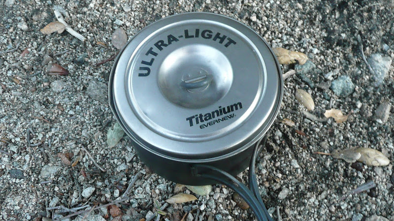 |
| An Evernew 1300ml titanium pot |
Well, "Ti" is short for "titanium" and refers to what the cone (not necessarily the pot) is made out of (titanium), and "Tri" refers to the fact that this is a triple fuel stove system. This stove system will run on three fuels: alcohol, hexamine (e.g. ESBIT), or wood. Now, if you've seen my previous posts on the Caldera Cone (see links at the bottom of this blog post), those were all aluminum cones. Aluminum Caldera Cones will warp and or melt if they get too hot, so you can only burn low heat fuels like alcohol or hexamine in them.
On the other hand, titanium cones can handle heat just fine. With a titanium cone, you can burn wood. Why might burning wood be an advantage? Burning wood is an advantage because you don't have to carry it on your back. I mean, think about it: When was the last time you saw fuel-grade alcohol welling up out of the ground? When was the last time you picked fuel off of the ESBIT tree? The point being that if you use alcohol or hexamine, you're not generally going to find it out on the trail. You have to carry the fuel with you. Wood on the other hand is frequently available from your surroundings.
To read the rest of the post go here.
Saturday, February 4, 2012
Snow Caves For Fun and Survival
My friend Leon reviews the book ‘Snow Caves For Fun and Survival.’
by Leon Pantenburg
A group of Boy Scouts and volunteers were on our annual winter survival skills training day in the foothills of the Cascades in Central Oregon. When it comes to snow caves, the conventional wisdom from most survival manuals, is that the builder tunnels sideways and up into a snow bank, shoveling the snow out through the entrance hole.
Naturally skeptical (because of my newspaper training) I asked my 17-year-old son, Dan, to construct one such shelter by himself, using a small shovel and trowel. More than two hours later, his cave was finished, but Dan was wet, tired and cold. Despite working hard, his cave was not a particularly effective survival shelter. Dan would have had a rough night ahead of him if he had to stay in that cave.
To read the rest of the post go here.
Wednesday, February 1, 2012
The Top Ten GPS Receivers
What are the top selling GPS receivers on the market?
Visit GPStracklog to find out what are the top ten receivers on the market.
"It’s that time again, when we look back at our reader’s favorite reviews for the previous month, which is indicative of what many folks are researching as potential purchases. And what a month it’s been, as we have two new number ones! On the auto side, the nuvi 2595LMT knocked out the 1450LMT, which had held the number one spot since April 2011. In handhelds, the eTrex 20 is the new reigning champ, after an incredible 13 month run for the Oregon 450. All told there are nine models on the charts that weren’t there last month. "
To get the complete list go here.