Map, Compass & GPS

Map, Compass & GPS
Wild flowers along Fall Creek on the way to the Green Lakes - Oregon

Wednesday, March 30, 2011

Powering Your GPS

What should you consider about the batteries in your GPS?


It was one of those famous “three little word” hunts – “I am just” (that’s three words) going to leave camp for a short hunt.  You know - grab the rifle, license and tags, ammo, GPS and head out for a short hunt; the hunter’s pack stayed behind.  Because he was just going down that game trail a bit the hunter didn’t need all his survival gear.  The hunter lost track of time and distance as he followed the fresh mule deer tracks, and, besides he had his GPS.  At twilight he recognized it was time to go back, the GPS showed him the way……until the batteries died.  Fresh batteries were in his pack back at camp.
In 13 years of teaching GPS classes I have had very, very few reports of a GPS breaking or failing electronically but I do hear about battery power draining at the worst time.
I’d offer a few suggestions:
·         Batteries will generally last for a reported 20 hours of continuous use; more on that shortly.  If you just turn it on, mark a waypoint and turn the receiver off the batteries will last you most of the hunting season.


To read the complete post go here.

Sunday, March 27, 2011

GPS Setup

http://outdoorquest.biz/gps_setup__using_the_right_coor.htmSetup your GPS to use the right coordinates and map datum.

     
A good friend has given you the coordinates to his favorite fishing spot at Elk Lake.  He was genuinely excited and pleased to give you this treasured location.  Now you can enter this information into you GPS and you will be all set.

Well maybe not.

A GPS is a very versatile backcountry computer and satellite receiver.  Today’s receiver can be taken anywhere around the world and when setup properly will provide accurate position information.  Coordinate information can be uploaded/downloaded to a PC and edited.

It is the setup process that our fisherman needs to be aware of.

There are two setup features that I’d recommend the user become familiar with.  These two features are the coordinate system used and map datum.

In my GPS classes these are topics of frequently lengthy discussions.

To read the entire post go here.

Saturday, March 26, 2011

37 Skiers Stranded

Skiers stranded in Yosemite.

37 skiers were stranded after a blizzard hits Yosemite National Park last Sunday and dumped six feet of snow.

Makes me wonder what was in their pack?

All made it out.

Read the complete post here.

Book Review

Peter Kummerfeldt has reviewed Les Stroud's new book.

Here is his post:

Friday, March 25, 2011

Tips On Using Your SPOT Loacator

Recommendations on using your SPOT beacon.

Shortly after the Kim Family tragedy in 2006, Global Star Telecommunications developed the spot beacon.

I have had excellent service with mine, a three year old model.

For complete details of the SPOT visit http://www.findmespot.com/.

Last fall I posted a short article on my website about SPOT.  I offered some suggestions on it's use.  Read it here.

A couple of thoughts come to mind.

  • Keep your contact list current.  Take contact names off your list (done on line via http://www.findmespot.com/) if they are no longer valid.  If someone is going to Hawaii on vacation they might not be the best pick now.
  • Only the most reliable people should be on your contact list. 
  • Practice with your SPOT before you leave.
  • Place it in your pack where the on/off button won't be accidentally pushed.

Thursday, March 24, 2011

Search and Rescue


What Search and Rescue wished we knew!

I came across this article in the Seattle Backpackers' online magazine.

In a story by Erika Klimecky the key topics that SAR wished we knew and would follow are discussed.

This is a fine post..

"Of course Search and Rescue hopes, as much as you do, that you never have to meet them in the backcountry. Still, once you know who they are and what they do, it’s just as important to be responsibly prepared when you go out into the wilderness. And yes, Si, Tiger and Cougar mountains, count as wilderness. Our weather, mountains and conditions in this area make for potentially problematic wilderness situations even 45 minutes from downtown Seattle."

To read the entire article go here.

Tuesday, March 22, 2011

HuntingGPSmaps

GPS software made specifically for the hunter!

Are you looking for GPS map software specifically designed for the hunter?

You need to check out Montana Mapping & GPS's software HuntingGPSmaps.com. 

Available for most Western states, this outstanding program accurately shows the boundary between public and private lands.
I used it during the 2010-11 hunting season in Oregon and was very happy with the data presented.

Primarily for Garmin GPS owners this software:

  • Data is taken from the most current survey records.
  • Accuracy is not less that 1:24,000 or +/- 50 feet
  • Maps are updated annually with the most current land ownership survey records.
I used the down loadable option.  The cost is a bit more but all future updates are free from the date of purchase.

If you are interested in more information email me at mapcompassandgps@gmail.com

Saturday, March 19, 2011

Map Reading Training For Children

Map reading does not come instinctively - it is a learned skill

First, let me say a big thank you to the Pineview Cub Scout troop for sending me a fine link to a web site that is designed to introduce children to mapping.

Map reading and the ability to absorb that information is not instinctive.  Map reading is a learned skill as is developing our basic skill to navigate.  And here I am talking about navigating around town.  It is wonderful to see how a very young person knows how to navigate (go straight, turn here) to school, the park and the store.  Our navigational efforts shape our subconscious ability to accurately navigate in the real world.

 Volunteering with Scouts - Feb. 2011

So, once again a big thank you to those fine Scouts and here is a link to the web site.

Friday, March 18, 2011

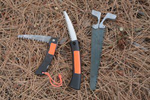
A Saw for Your Pack or Camp

Peter Kummerfeldt has written a great post on what kind of saw should be in your survival pack.

Just as informative are his comments about why he won't carry an axe into the woods.

Importantly, he discusses the concept that all his gear can be used with one hand.  One hand operation is particularly true if the user is injured.

Read his complete post here.

Thursday, March 17, 2011

Topographic Maps

A good topopraphic (topo) map is the hikers best companion on the trail.

Unlike a road map, your topo will provide you elevation and altitude information, trail data,and water sources.

My personal favorite source for my maps is the Terrain Navigator program from MyTopo.  This is a very robust program used by hikers and SAR teams across the country.  For more info on Terrain Navigator, visit here.  I have been using this software since 1998 and am very happy with it.

MyTopo also offers custom mapping options.  These maps are not cheap but they are a wonderful product. http://www.mytopo.com/.

There are several other products out there from Delorme and National Geographic.  The National Geographic maps of our National Parks are excellent.  The detail is great, it is printed on a waterproof paper with UTM grids laid out.

To view and learn the many topo symbols check out the USGS site here.

To read one of my posts on navigating a topo map go here.

Monday, March 14, 2011

Hiker's Day Pack

What should you have in your hiker's day pack?

Frequently I am asked "what should I carry in my day pack?"

There are lots of check lists out there. 

Cabela's and REI both have check lists that you can down load from their web sites.

I recently got a copy of Peter Kummerfeldt's list of what goes in his pack.  Check here.

Another resource to consider is John McCann's book, "Build the Perfect Survival Kit." 

No matter how big your check list, keep your day pack to a manageable size.  If your pack is to heavy for a day hike, adjust it to meet your needs.  It has to work for you on the trail.  For a list of the minimum of what to take a previous post is here.

Sunday, March 13, 2011

GPS Waypoints

Trust but verify that the GPS waypoints that you have marked are saved.

There is nothing magic here.  Then again, there is nothing worse than that sinking feeling when you are in the backcountry, it's time to return the trailhead, you select "trailhead" and that waypoint isn't listed in the waypoint library.

So here are a few suggestions about marking a waypoint.

  1. While driving to the trail head, place the GPS receiver on the dash and let it begin receiving satellites.
  2. After parking, place the receiver on the hood or in a spot where it will have a good sky view.
  3. Take a look at the satellite information page.  (On some models you may have to go to your "main menu" page to find this display.)  Ideally you will find that the receiver is tracking more that 4 satellites.  There should also be an indication that you have a "3D" position fix; "2D" is not acceptable.
  4. Mark your waypoint as usual.  Perhaps you will give it a name; trailhead.
  5. Now verify that the waypoint has been saved.  This is key.  I find that there are two easy ways to do this.
    • Select the "Find" or "GoTo" button or option.  The waypoint number or name (that you typed in) should be found in your library of saved waypoints.
    • OR, using the page button, go to the map page and you should see the waypoint name visible.  If your receiver zoom setting (as in zoom in or zoom out) is at 20 miles, you may not see the waypoint name.  I keep my zoom setting at 800 feet while hiking and this allows me to clearly see the waypoint name or number (see below, Elk1 is the saved waypoint.)


Another option is to look at your waypoint list.  Select "find," then "waypoints" to take you to the list.  Notice that Elk1 is there too.


If the waypoint isn't there or listed I'll use my track log to help me get back. 

When I am on a hike I will keep my GPS in a case that clips to the shoulder straps of my pack and I leave it on all day.  Batteries are cheap.  At the end of the day I could follow my track history back to the trailhead.


Friday, March 11, 2011

Earthquake

This is a good time to take a look at your earthquake preparation.

My friend Leon has a very timely post about earthquake preparation here.

Helping the Searchers

It is late in the afternoon and you realize you have no idea where you are.  What can you do to help the searchers.

SAR teams around the country are made up of volunteers that are dedicated to finding and helping people lost and injured in the backcountry.

They spend hours in training.  They participate in mock mission to tune their skills.  They are called out during the middle of the night.

What most don't realize is that frequently teams are asked to support an effort outside of their area of responsibility.

Helping the searchers begins before for your trip afield.  It starts by taking the right gear and providing a trip plan to that responsible person that will be your link to 911 should you be delayed due to an unfortunate circumstance.

To read more of what you can do check out my article here.

Wednesday, March 9, 2011

Backcountry Stoves

I really appreciate a helpful blog.

A great site on backcountry stoves is by Hikin Jim.  I found Jim's blog on Doug Ritter's http://www.equipped.org/ some time ago.

If you are looking for info on the various types of fueled, packable stoves take a look at AdventuresInStoving here.

Lots of info, great photos and many reviews on the various types of stoves out there; old and new.

Monday, March 7, 2011

A New GPS & Refresh Your GPS Skills

For many, their outdoor season is over until spring.  But right now many stores and online sites have some very good prices on GPS receivers.  Check Cabelas or Amazon.

The Garmin Map 60 series is probably no longer in production but you can find this excellent GPS for excellent prices.

Whether you buy an new one or keeping the old one, this is a great time to brush up on your GPS skills.

I'd suggest couple this with a short tune up on you map and compass skills too; they go hand in hand.

I wrote an article on getting up to speed here.

Sunday, March 6, 2011

More Kummerfedt

I sat in on Peter Kummerfedt's seminar yesterday.  His topic was "Survival Myths and Misconceptions."

He goes after the hogwash published in our outdoor press and magazines about wilderness survival.  He has been monitoring this for years.

Peter critiques the articles that have been published over the years that talk about shelters, fire starting and backwoods lore.  These articles are supposedly providing the skills that an outdoorsman should learn to survive and get by in the outdoors in an emergency.   One really has to wonder what these writers are thinking.

Example after example, Peter tears apart recommendations from these articles.  I remember onearticle that discussed building an emergency shelter that looked like something our Northwest Native Americans would build.  Oh really, a lost hiker would build that.  Peter is more blunt.

It makes me think that the only survival situation that these writers have been in is when they lost power to their lap top.

Sadly, year after year, our outdoor magazines perpetuate these myths.  This shines the light of truth on these magazines and highlights their lack of integrity.  It causes me to question the validity of any of the articles.

Saturday, March 5, 2011

Rocky Mountain Elk Foundation

This weekend Cathy and I are in Reno for the Rocky Mountain Elk Foundation (RMEF) convention.  It is  a smaller show but, still, it has been fun.

Its is encouraging to hear that in the 27 years since RMEF was founded, 5.9 million acres of habitat have been conserved.  Just like the great work of Ducks Unlimited, when habitat is improved for the elk, habitat is improved for all wildlife.

The RMEF convention has many fundraising opportunities for attendees.  A lot of money was raised for habitat.  A young lab pub was auctioned for $10,500.00.

RMEF also has special opportunites for our wounded warriors coming back for Iraq, Afganistan  and the Fort Hood shooting.  This year a young soldier shot 4 times at Fort Hood was honored.  RMEF has a special bond with these wonderful Americans.

The RMEF convention also has wonderful seminars hosted by many back country legends such as Jim Zumbo and Ron Dube.

Among the best are the presentations given  by Peter Kummerfeldt.  Peter is a retired USAF survival training technician.  After retiring with 30 years of service in the mid 1990's, Peter has been a big game guide and the owner of his business, Outdoor Safe; visit http://www.outdoorsafe.com/.

Peter and his wife Mary travel the west each year hosting seminars and training for outdoor men and women as well as training US Coast Guard rescue swimmers and US Customs staff.

For the outdoor men and women, hikers, hunters, and backcountry travelers in general, Peter's seminars are first rate.

You aren't going to learn primitive skills.  Primitive skills are fine but they take a lot of time to master.  Peter's focus is to prepare you using modern skills and equipment to survive that unexpected night out or accident.

Generally at a Sportsman show he will host between two and three seminars a day.  Price of admission into the show also gets you into the seminars.

Sure, bring a pad of paper and pen but I doubt if you can write fast enough.  You will learn about emergency management, fire starting, shelter building, signaling and much more.   Peter will also skewer those survival myths that have been perpetuated of the years.   Once you take his seminar you will want to come back for more.   Thankfully there is no quiz at the end.

But best of all, if you have more questions or want to learn about a particular skill, follow Peter back to his booth.  He will put the gear in your hands and you'll learn by practical experience.

At the seminars this year at RMEF, Peter reported that 37 people have now attributed the information he presents to having saved their or that of a family member's life.  They have put into practice the practical skills that Peter has taught them.  Now that is a hallmark I'd be proud to own.

Wednesday, March 2, 2011

It Has To Work For You

During the course of teaching GPS classes for over 12 years and now wilderness survival I have become attached (so to speak) to a phrase, "It has to work for you."

There is nothing magic here.  Nothing novel.  Nothing original.

People enjoy talking about new technology, equipment or skills that they have learned.  They are justifiably proud of their new knowledge. 

A good friend got me very interested in using an alcohol stove while backpacking.  It is economical, takes up little space and weighs but a few ounces.  The problem is, that I can't get mine going reliably.  I need more time with it to learn the basics; how simple can that be.  But still, it is not working for me.

In SAR training two years ago, one team member told me how a computer mouse pad is great as a stove platform, in the snow while winter camping.  So I try it out.  I accidentally spill come Coleman white gas fuel on the pad.  When I light the stove, of course the pad catches on fire; just great.  The spot fire on the pad quickly burned out and just singed the top surface of the pad other wise it was just fine.  This works for me.

There are a lot of books out there on backcountry travel and survival.  Survival has become very popular.  I suggest reading these with a critcal eye.  If there is a particular technique or skill set that you want to adopt, test it at home first.  Though the author may be on the speaking/sportsman show circuit, has his own cable show or is repeatedly on network news be critical.  Remember, when you are in a jam, you are repsonsible for you. 

Become cautious when reading old and dated material.  For example, in the late 1960's I was given a copy of Colin Fletcher's book, "The Complete Walker."  This book got me hooked on backpacking.  That said, the book is based on lessons and experiences from almost fifty years ago.  Doing some research and review of current methodology may be best.


Interestingly, I am hearing from my students more often,  "I heard this was used by the Special Forces," or "I read in a magazine that this is what Special Forces do." Well, OK, but is that really true or better yet, is that important for your needs.  It gets down to research and experience.

Let's consider land navigation.  It is a practiced yet perishable skill.  You need to be on your game.  If you are the team navigator, you skill and techniques have to work for everyone.

So my point would be, as you prepare for a trip or hike, as you put new gear into your pack, test it in advance.  Make sure it works for you.

Tuesday, March 1, 2011

Norwegian Mountain Code

I enjoy reading about backcountry travel.  I am also interested in what is the right gear to carry.

I came across the Norwegian Mountain Code last year. 

It's pretty simple.

In 1967, Norway tragically lost 18 outdoors men during the Easter weekend.  Later the Norwegian Red Cross and Norwegian Mountain Touring coordinated the development of the code; a common sense approach to back country winter travel.

The code compliments the Ten Essentials and builds on it.  Read about the code here.