

- Ensure the
compass is “on the mark” in terms of correct declination adjustment, the
setting of the Direction of Travel Arrow and the alignment of the compass
to the bearing (are you really pointing in the right direction.)
- Pick the best
land marks to work with such as pinnacles and spires and pronounced land
marks; the choices may be limited.
There are several factors that impact accuracy that the
hiker may have no control over but should be aware of. Some of these
include:
- The
quality of the hiker’s vision.
- Polarity
of the compass’ magnetic needle – does it point in the right direction?
Polarity may change over time such that the magnetic needle my no longer
work accurately.
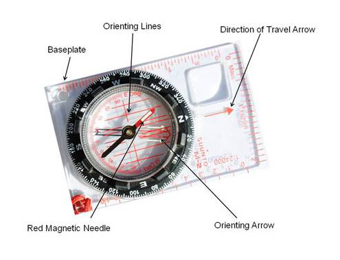
- Smooth
movement of the magnetic needle.
- Alignment
of the compass dial to the compass housing.
- Local attraction – Similar to declination, local
attraction is magnetic interference unique to a specific location. It may be caused by buried metal objects
or an unusually high concentration of iron or nickel in
the ground.
 Navigation is not hard but it does take practice; it is a
perishable skill. I recommend to those
in my classes that a minimum of two weeks before a backcountry trip that the
GPS, map and compass goes everywhere with them. Practice in the field or at the park. Take the time to compare the three with what is
seen.
Navigation is not hard but it does take practice; it is a
perishable skill. I recommend to those
in my classes that a minimum of two weeks before a backcountry trip that the
GPS, map and compass goes everywhere with them. Practice in the field or at the park. Take the time to compare the three with what is
seen.
When in the wilderness compare both map and compass with
a GPS when possible. Hiking companions
should compare their work too.
Familiarity with your equipment will make you a more
skilled advocate for your safe return.


 Hands on review of the DeLorme inReach for Android

