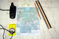
Reviewing a topographic map is usually the starting point for the planning of any back country trip. A topographic map is your road map to the outdoors. It provides you detailed information at a scale that is meaningful and detailed. For years, the US Geologic Survey (USGS) has been the principal publisher of accurate maps. Within the last decade we have seen many innovations in mapping products that include new mapping companies and publishers, software, maps for the GPS, and “Apps” for the iPhone.
 |
| Outdoor Quest/Blake Miller image |
Still, the USGS map remains the standard for back country navigation (visit the USGS’s site at www.topomaps.usgs.gov.) I’d also recommend looking at June Fleming’s “Staying Found” or Bjorn Kjellstrom’s “Be Expert With Map & Compass.” Once you develop a map foundation you will easily shift to many of the other products on the market today.
Many publications, videos, and web sites will give you a te rundown on the features, symbols and components to a map. This article will discuss a few of the key features that you should be aware on a 7.5 minute map.
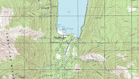
· Contour Lines These are the thin brown lines that snake across the map. Contour lines connect equal points of elevation such that every point on that line will be at that elevation above sea level. Visually, the contour lines give you a mental three dimensional view of the terrain. These lines provide a view of slope and pitch, depressions, ridge lines and level ground; the highs and lows of the earth’s surface.
 |
| Outdoor Quest/Blake Miller image |
These lines provide shape and a sense of texture. There are two primary types of lines, index and intermediate lines. Index lines stand out as they are a touch wider, a darker shade of brown and indicate the elevation with numbers such as 4500; the elevation is in feet. Between the index lines are the thin intermediate line that are spaced uniformly and further define the elevation, slope and contour. The intervals between the intermediate lines are specified at the bottom of the map adjacent to the scale data.
· Scale Consider scale as your view of the map; it is like your “overhead zoom” setting. To cut to the chase, a 7.5 minute map or quadrangle has a scale that is referred to as 1:24,000; where one inch is equal to 2000 feet. It is your best source of information of the back country. At this scale, the map has much more validity and provides more usable information for your backcountry planning. You can view important landmarks, streams and geographic features. To complete the navigation picture I always refer a second map, such as a map of the national forest (e.g., the Deschutes National Forest.) Commonly, such a map will be “zoomed” way out and have a scale of 1:100,000 or 1:250,000. Imagine that such a map would be made up of many 7.5 minute quadrangles.
· North Features on a map such as trails, roads, mountain peaks and streams are all laid out in relation to true North; the North Pole. The north-south borders of the map and the small declination diagram are your best references for true North. Other grid lines (such as the red Township, Section and Range lines) may not be aligned to true north at all. Be careful of these lines should you need to triangulate your position on a map.
· Declination This is the angular difference between true North and Magnetic North. The red needle on your magnetic compass points to Magnetic North. The accuracy of the information found in the Declination Diagram is dependent on the age of the map. To get the latest declination for any area visit www.magnetic-declination.com.
Personally I use a magnetic compass that I can adjust for declination; it just makes my navigation easier. When adjusted, my compass provides bearing information in degrees true as does my map and my adjusted GPS.
· Coordinates Latitude and Longitude (Lat/Long) are the familiar coordinate system to most outdoorsmen and women. Coordinate data is found at the top and bottom corners of each map. Lat/Long coordinate increments are also found every 2’ (minutes) and 30” (seconds) on the sides of the Map. A scaling device is necessary to pull complete coordinates off a map; this is a pain.
In the 1940’s a coordinate system know as Universal Transverse Mercator (UTM) was developed. To keep a very long story short, your 7.5 minute map has a new grid laid over it, the grid dimensions are 1000 meters by 1000 meters. For more complete information on UTM grid visit the USGS’s web site UTM or Lathem’s “GPS Made Easy” (which is probably at your local library.)
Simplicity is the essence of UTM. Scouts, hunters and hikers have joined Search and Rescue (SAR) teams around the country in using this system.
Your GPS receiver can easily be switched to UTM from the set-up menu.
· Bar Scales Notice the bar scales at the bottom of the 7.5 minute map. The scales provide measuring data in miles, feet and meters. On the far left side of the meter scale, the scale is broken down into units of 100 meters, this applies directly to UTM.
Notice on the scale bar (feet) that 1 inch equals 2000 feet.
· Map Datum Information about map datum is found in the lower left corner of a 7.5 minute map. I have found that the simplest definition from GPS maker Garmin is:
“A math model which depicts a part of the surface of the earth. Latitude and longitude lines on a paper map are referenced to a specific map datum. The map datum selected on a GPS receiver needs to match the datum listed on the corresponding paper map in order for position readings to match.”
The bottom line: most 7.5 minute maps are made to the North American datum of 1927 (NAD27 or NAD27 CONUS on your GPS). New GPS receivers are set to datum WGS84. The difference between the datum could be over 100 meters/yards. The solution: When pulling points off a map shift your GPS’s datum to match the map.
If precision is not an issue for your outing don’t worry about datum.
As you begin your trip planning don’t forget the magnetic compass, the important partner to any topographic map. See Selecting a magnetic Compass for more information about buying a good compass.
|