Map, Compass & GPS

Map, Compass & GPS
Wild flowers along Fall Creek on the way to the Green Lakes - Oregon

Monday, October 19, 2015

Celestial Navigation


I learned celestial navigation back in the 1970's. My son is a serving naval officer and told me several years ago that the US Navy no longer used or practiced celestial navigation.

That policy is in for a change.

The following article is from Defenseone.com and is written by Steve Mollman.

"Satellites and GPS are vulnerable to cyber attack. The tools of yesteryear are not.

Sometimes old school is best. In today’s U.S. Navy, navigating a warship by the stars instead of GPS is making a comeback.

The Naval Academy stopped teaching celestial navigation in the late 1990s, deeming the hard-to-learn skill irrelevant in an era when satellites can relay a ship’s location with remarkable ease and precision.

But satellites and GPS are vulnerable to cyber attack. The tools of yesteryear—sextants, nautical almanacs, volumes of tables—are not. With that in mind, the academy is reinstating celestial navigation into its curriculum. Wooden boxes with decades-old instruments will be dusted off and opened, and students will once again learn to chart a course by measuring the angles of stars."


Read Mr. Mollman's complete post.

Wednesday, October 14, 2015

Important Considerations When Working with Maps


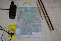
When working with maps there are some key points to remember, especially when using a map in conjunction with a compass and a Global Positioning System (GPS) receiver.

Datum

Maps made based on a datum (horizontal and vertical).  Datum is the origin from which all points on a map are measured. Three primary datum have been used to develop maps in the United States.  These are:

  • North American Datum of 1927 (NAD27)

  • North American Datum of 1983 (NAD83)

  • World Geodetic System of 1984 (WGS84).

Datum is a mathematical model that accounts for developing a map from a spheroid (the earth) to a flat map.

When using a GPS receiver the datum must be set to match the horizontal datum on the map. If the datum does not match, there will be errors when plotting data on a map.

Map datum information is found in the title block at the bottom left corner in the margin of a USGS map.  Other maps (e.g., US Forest Maps and commercial maps) seemingly provide datum in rather random locations. The hiker will have to scan the map to find this information.

Geographic North

Maps are laid out in relation to geographic North (also referred to as the north pole or true north.) This is important to remember because the traditional magnetic compass provides information based on magnetic north.  Magnetic north changes over time, while geographic north does not change. The difference is referred to as magnetic declination. When using a compass and map together the hiker must account for this difference.   Because of this I recommend that the navigator have an adjustable compass such as the Sylva Ranger.

For more on declination go here.

Maps Are Not Perfect

For a map to be considered reliable and accurate, map symbols marked on a map must be in proper relation to known landmarks or positions located on the ground.  In 1947, the “United States National Map Accuracy Standards” were established as the standards of accuracy for published maps and are currently in effect. The standards require a stringent percent of accuracy within centimeters of both location and elevation of points tested. However, even with these standards, maps are not absolutely accurate because:

  • Maps represent a curved and uneven surface that is drawn on a flat piece of paper, which results in a distorted picture.

  • There is a margin of error (human error and inadequate survey procedures) in surveys that were used to create maps. Also, there are factual matters (errors such as names, symbols of features, and the classifications of roads or woodlands); sometimes the information is wrong and names and features change.

  • If a map has been photocopied, it most likely is not to scale.

  • Maps editions are dated and not current.

Maps do not accurately represent the ground surface

Topographic maps provide an overview of the ground surface.   A USGS 7.5 minute map uses  a scale of 1:24,000.  This means that 1” of map distance equals 2000’ feet on the ground.  1square inch on the map is equal to 91 acres on the ground.
The symbolic information provided by colors provides only a general description on the ground.  For example, green coloration refers to vegetation such as forested areas.  But what color does not tell you what is the surface really like?  The map doesn’t tell the hiker if the area is full of brush, blown down trees or large area of loose rock.

Resolution

Though maps are not perfect there are things the hiker can do to lessen the issue with maps.  Here are some suggestions:

  • Review trail guides of area to be visited.

  • Visit with other hikers that have been to the same area earlier.

  • Visit  with government agency officials  such as:

    • Forest Service Backcountry Rangers
    • Fish and Game law enforcement officials.
    • Biologists
    • Search and Rescue organizations  in the county to be visited
    • National Park Rangers


The reference for this post is Basic Land Navigation produced by the National Wildfire Coordinating Group (NWCG.)  This is a straight forward document that covers the essential elements of land navigation: it is a good introduction and the source for this post. This is a free publication.  Down load it here:  http://www.nwcg.gov/sites/default/files/products/pms475.pdf. 


Saturday, October 10, 2015

Stay On The Trail

Sectionhiker.com has a solid post about not going off trail and the damage off trail travel can do.

Have you ever seen someone trampling rare lichens above tree  line by hiking outside designated trails? Camping illegally on an open summit? Cutting down krumholz to fuel a fire? Carving their initials into a shelter? Building a new fire ring? Washing their dishes with soap in a wilderness pond? Knocking over rock cairns? Breaking live tree branches near a campsite for a fire? Digging a trench around their tent to drain rain? Leaving toilet paper on top of the ground? "


Sectionhiker.com has lots of good discussion topics with this post.

Friday, October 9, 2015

Stove Efficiency

Hiking Jim at Adventures in Stoving has a fine post to evaluate if a stove is operating efficiently.  He also has some suggestions to setup a stove for peak performance.


Thursday, October 8, 2015

Understanding Magnetic Declination

Declination: A Noun. The horizontal angle between the true geographic North Pole and the magnetic North Pole, as figured from a specific point on the Earth.”


 Declination is a term that causes “brain cramps” for many of my students in my map and compass classes. When I mention Magnetic Declination eyes roll.


The web site www.magnetic-declination.com has an excellent discussion of what declination is and what causes it:


“Magnetic declination varies both from place to place, and with the passage of time. As a traveler cruises the east coast of the United States, for example, the declination varies from 20 degrees west (in Maine) to zero (in Florida), to 10 degrees east (in Texas), ......the magnetic declination in a given area will change slowly over time, possibly as much as 2-25 degrees every hundred years or so.......... Complex fluid motion in the outer core of the Earth (the molten metallic region that lies from 2800 to 5000 km below the Earth's surface) causes the magnetic field to change slowly with time."

Land navigation is based on the relationship to the North Pole; also known as “true north.  The measure of degrees of direction in relation to true north is called “degrees true.”  Maps are laid out in degrees true.  Land features (buttes, mountains, streams) on a topographic map are in reference to degrees true.  By that I mean the bearing from one mountain peak to another will be referenced in degrees true.  The map below illustrates that point. 


Magnetic compasses do not point to true north (the North Pole); the magnetic needle points to an area that could be considered the magnetic North Pole. 
As illustrated below, declination data can be found in the diagram at the bottom of a USGS topographic map, (on some commercially produced maps it can be hard to find.) 

Because declination changes over time, I recommend that map declination information be verified at www.magnetic-declination.com.   This is essential in the Pacific Northwest where maps are notoriously out of date in terms of road,  and city data.
So, how do we make this simple?  How do we convert magnetic to degrees true?
I could do the math.  In Oregon, where I live, the magnetic declination is 15.6° East declination.

My recommendation: have the compass do the work so that there is no confusion with the math.

To do this, I need to choose a compass that can be adjusted for declination.  Some examples are the Silva Ranger or the Suunto M3.

With one of these compasses, the compass dial or housing is adjusted and rotated manually.  Both the Suunto and Silva Ranger come with a small, flat adjusting tool.  Consult with owner’s manual that came with the compass.

If declination is Easterly (Western U.S.) I will rotate the dial causing the baseplate’s orienting arrow to move in a clockwise direction.

   If declination is Westerly (Eastern U.S.) I will rotate the dial causing the baseplate’s orienting arrow to move in a counter-clockwise direction.

Now, adjust the dial and align the red magnetic needle on top of the orienting arrow (the red arrow engraved on the baseplate) the compass will provide directions in degrees true.

Sunday, October 4, 2015

Buying A New Compass


Silva Ranger  - Outdoor Quest Image
There are several things to keep in mind when buying a compass.

My preferred compass is a declination adjustable sighting compass like the trail proven “Silva Ranger.” (Silva, Brunton and Suunto all make good compasses.) The key is that this type of compass can be adjusted for magnetic declination and that keeps your wilderness navigation simple. You can expect to pay roughly $35.00 - $60.00; a cheap compass will not serve the hiker well.

My experience is that most sales clerks are compass illiterate and have little navigation experience.  While looking at a compass ask the clerk to remove it from the plastic container/packaging.  Check the compass to ensure:

  1. The dial moves freely and does not stick.  There are no bubbles internal to the compass housing.
  2.  Information engraved on the base plate must be legible.  If there is a magnifying glass verify that it is clear and not scratched. 
  3. The tick marks on the dial are in two degree increments.  The tick marks should be readable.
  4. The base plate, rotating dial assembly, and mirror are not chipped or broken.  
  5. The sighting assembly hinge allows freedom of movement without excess side to side movement at the hinge .

 Packaging should clearly state that the compass is declination adjustable.  Adjustable compasses may have a small metal tool that allows for setting the declination.  If the packaging states that the compass has declination marking but does not use the word adjustable move to another model.

After purchase visit the website www.magnetic-declination.com to determine the declination of the area the hiker will be traveling through.


Remember that the red magnetic needle will always point to magnetic north.  With a declination adjustable compass the rotating dial has been adjusted so that the information provided by the compass is now in degrees true.

Saturday, October 3, 2015

Is It Time To Replace Your Compass?

When should the hiker replace a compass:

  1. When there is a large bubble in the compass housing.
  2. When the compass body is scratched or cracked.
  3. When the sighting mirror is damaged or the hinge allows for excessive movement.
  4. When the compass polarity has been degraded.  For example, if you can identify that the compass is not providing accurate information (e.g., doesn't point accurately to true north.)   This could be true of an older compass.
  5. When lettering on the rotating dial is worn and abraded.
  6. When the rotating dial is stuck and won't freely move.
  7. When the magnetic needle has fallen off it's pivot point.


Thursday, October 1, 2015

Compass Interference

A magnetic compass needle’s movement is based upon the earth’s magnetic field.  That magnetic field and the movement of the magnetic needle on its pivot point in part, determine direction.

Ideally, there is no interference from any objects.

But that is not reality.  Nickel near the earth’s surface, rifle barrels and power lines all interfere with the compass’ movement.  What are the standoff distances that the hiker need observe?

I went to two publications to get that answer.  Camping and Wilderness Survival by Paul Tawrell (page 177) and GPS Land Navigation by Michael Ferguson (page 53) became my sources.

Metal Object
Ferguson
Tawrell
Power Lines
55-60 meters
55 meters
Truck/Car
18-20 meters
10 meters
Telephone wires/barbed wire
8-10 meters
10 meters
Rifle/hand tools
2-3 meters
-
Pocket knife/binoculars/electronics
½ - 1 meter
-
Shovel
2-3 meters
½ meter

Interesting data points to consider.  For example, if you combine the bottom three rows of information it becomes common sense to ensure the hiker’s gear is out of the way. 

Neither reference identifies the amount of impact these objects will have on the compass needle.  That is not practical for the average hiker.  It is the hiker's movement away from the object (.e.g., fence or car) to mitigate the error induced.

I would also offer that one should be careful how close to a compass electronics are stored in a pack.  I’d just keep it simple by stowing the flash light, GPS receiver and camera in a pack pocket/compartment away from the compass.


Note that GPS manufacturer Garmin recommends moving away from metal objects when calibrating the GPS receiver’s electronic compass.