Map, Compass & GPS

Map, Compass & GPS
Wild flowers along Fall Creek on the way to the Green Lakes - Oregon

Monday, May 14, 2012

Green Trail Maps

Another source for maps.

About Our Maps
Mt Hood Climbing Map - 462SG

Green Trails, Inc founded in 1973, publishes over 140 topographic recreation map titles for the most spectacular mountain, beach, canyon and urban areas of North America. Green Trails maps show the most current trail, road, and access information in the most clear, compact, and convenient format and scale available.

Visit their site here.

Sunday, May 13, 2012

Helping the Searchers


It’s 4:00 in the afternoon and weather conditions are worsening. It has been a long day that started well before first light. As darkness approaches you recognize that the hunt is over and you have no idea where you are, really are. You have your pack with the right gear and extra food. So, what are your options and how can you and help the searchers?

Search and Rescue teams are dedicated volunteers and professionals found in each county and province across North America. They spend hours in training, certifications, and on missions looking for the lost and injured.

Helping the searchers begins at home well before the trip or hunt. In Hunter Education, students are taught to always let a responsible person know where you are going and when you are expected to return. If you don’t return, they are to call 911. But there is more to it than that. I suggest that your fill out a Trip Plan (visit the Link page at www.outdoorqest.biz for the plan) just as a pilot would fill out a flight plan. This plan gives the searchers more to go on; details are important to the searchers. A vague statement of “he said he’d be hunting off the 400 road by Ball Butte” doesn’t help much. Your trip plan should cover a lot more information such as the coordinates of your start point and camp, license plate numbers of your vehicle, a comment regarding any medical issues and the names of your partners in the wilderness. Attach a map of your hunt area to the Trip Plan too.

To read the rest of the post go here.

Thursday, May 10, 2012

Finding Direction Without a Compass

Preparation and carrying the ten essentials is vital to any outdoor trip.  Map, compass and GPS make up my navigation kit.  Still, the unplanned happens and the magnetic compass may be broken or left at home.  Knowing a few common practices can make a difference.


How can you determine direction without a compass or when the compass is broken?

There are a few viable techniques that can be used to determine direction.  But first, let’s eliminate two methods that are not practical.

Let’s eliminate the old axiom of moss growing on the north side of a tree.  It is just not reliable.

Secondly, dismiss the concept that deciduous trees (e.g., oaks, maples) develop significantly more vegetative structure on a southern exposure.  Generally, one would expect more branch development and canopy on the southern side because of the amount of sunlight received.  This is getting a lot of attention on the internet.  In the Pacific Northwest the Forestry professors that I have discussed this with tell me not to depend on such an observation.

The following are a few methods that are worth remembering.
To read the rest of the post go here.

Wednesday, May 9, 2012

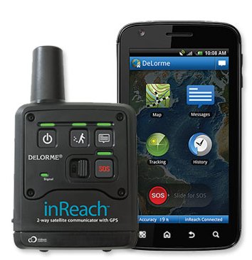
Delorme inReach Review

The folks at Tracklog.com have a great review of the Delorme inReach.

Hands on review of the DeLorme inReach for Android

The DeLorme inReach for Android pairs with compatible phones to offer two-way texting without cell service, as well as two-way SOS, tracking and positing to Facebook and Twitter. The device can also be used in standalone mode. A model that pairs with the DeLorme PN-60w is also offered.

The big advantages offered by the inReach are true global coverage (unlike SPOT devices) and two-way communication.

To read the rest of the post go here.

Thursday, May 3, 2012

Topographic Map Essentials


A topographic map is your road map to the outdoors. It provides you information at a scale that is meaningful and detailed. Reviewing a topographic map is usually the starting point for the planning of any back country trip. For years, the US Geologic Survey (USGS) has been the principal publisher of accurate maps.

Within the last decade we have seen many innovations in mapping products that include new mapping companies and publishers, software, maps for the GPS and “Apps” for the iPhone.

Still, the USGS map remains the standard for back country navigation (visit the USGS’s site at www.topomaps.usgs.gov.) I’d also recommend looking at June Fleming’s “Staying Found” or Bjorn Kjellstrom’s “Be Expert With Map & Compass.” Once you develop a map foundation you will easily shift to many of the other products on the market today.


To read the complete post visit  Seattle Backpackers Magazine here.

Wednesday, May 2, 2012

Navigating a Topographic Map

Knowing how to use a topographic map is vital to any back country outing!

<><><><> <><><><> <><><><> <><><><> <><><><> <><><><>


Reviewing a topographic map is usually the starting point for the planning of any back country trip. A topographic map is your road map to the outdoors. It provides you detailed information at a scale that is meaningful and detailed. For years, the US Geologic Survey (USGS) has been the principal publisher of accurate maps. Within the last decade we have seen many innovations in mapping products that include new mapping companies and publishers, software, maps for the GPS, and “Apps” for the iPhone.


Still, the USGS map remains the standard for back country navigation (visit the USGS’s site at www.topomaps.usgs.gov.) I’d also recommend looking at June Fleming’s “Staying Found” or Bjorn Kjellstrom’s “Be Expert With Map & Compass.” Once you develop a map foundation you will easily shift to many of the other products on the market today.


Many publications, videos, and web sites will give you a complete rundown on the features, symbols and components to a map. This article will discuss a few of the key features that you should be aware on a 7.5 minute map.

To read the rest of the post go here.

Controling Panic

Peter Kummerfeldt has a new video out about controling panic when you are lost.

Colorado Parks and Wildlife produced this one.

To view the video, go here.