Map, Compass & GPS

Wild flowers along Fall Creek on the way to the Green Lakes - Oregon
Sunday, July 31, 2011
OutdoorSafe with Peter Kummerfeldt: Survival Christmas Island Style
OutdoorSafe with Peter Kummerfeldt: Survival Christmas Island Style: "The guide catching our lunch Tony preparing a fire Lunch being cooked It doesn't get much better than fresh fish for lunch! ..."
Thursday, July 28, 2011
Prepare, Practice These Tips to Keep Kids Safe in the Outdoors
By Leon
In an instant, the backpacking trip in Idaho’s Sawtooth Mountains turned from an idyllic family outing to every parent’s nightmare. One moment, my son Daniel, 16 months old at the time, was playing around the campsite. In the next, despite the close supervision of four adults, he had vanished.

The adults immediately split up to search for Dan. I sprinted back down to the lake, while my wife, Debbie, ran the other way, up the hill. Out of the corner of her eye, Debbie caught a flash of Dan’s bright red jacket as he disappeared over the rise. She collared the would-be wanderer, who thought the chase was part of a game.
We took my oldest son, Dan, on his first backpacking trip when he was five months old. Debbie carried him and all the paraphernalia associated with an infant, and I carried all the camping gear. When my brother, Mike, went backpacking with us, he and I would split the weight up. We didn’t go far, but we still managed to get back into the mountains, away from most of the crowds.
To read the rest of the article go here.
Though warmly dressed, this youngster would be hard to find if she got lost in the winter woods. Her clothing blends in with the surroundings and there is no whistle attached to her coat.
We took my oldest son, Dan, on his first backpacking trip when he was five months old. Debbie carried him and all the paraphernalia associated with an infant, and I carried all the camping gear. When my brother, Mike, went backpacking with us, he and I would split the weight up. We didn’t go far, but we still managed to get back into the mountains, away from most of the crowds.
To read the rest of the article go here.
Sunday, July 24, 2011
Dump the Junk - Managing your waypoints

Robin is one happy GPS user. He has owned his Garmin GPS 60 for two years. The Waypoint file is full of entries. He had recorded hunting trips, camping expeditions with the kids, a few geocaches, and of course the favorite fishing spot. His GPS receiver will hold 500 Waypoints and he has over 350 saved. What a collection of data. But is Robin really managing his Waypoints effectively?
Nope.
Lots of things can happen to a Waypoint or data file. You can put data in. You can take data out. You can lose it (the GPS breaks or the wrong button entry is selected.) But be careful, far worse, too much data can make your navigation difficult.

In my land navigation class I stress keeping your navigation simple. Frequent and simple Waypoint management is essential to GPS use. When it’s time to return to the truck, it should be obvious what Waypoint to select.
Dump the junk before the start of a trip. As you leave the trail head your GPS should have only necessary data saved on your GPS. That Waypoint for the fishing hole is important but needs to be saved elsewhere.
Start by deleting Waypoints that really are not needed. Free those data bites to the atmosphere.
To save your “got to have, must save Waypoints:”
- Use Garmin’s “Trip and Waypoint Manager.” It probably came with your GPS. It can also be purchased from Garmin for about $30.00; www.garmin.com. Down load those Waypoints to your PC.
- If you don’t have the Garmin program, consider “Easy GPS.” It is free and available at www.easygps.com.

- Log the important data in a notebook.

To read the rest of the post go here.
Hike Safely
Carrying the right equipment and knowing the trail conditions is essential to safe travel in the backcountry.

Parking their car by Sparks Lake, they hiked in and encountered a trail partially covered in snow and crisscrossed with blown down trees. It was not an easy trek but they moved forward. As darkness fell the husband recognized they were lost. The weather changed, temperatures dropped and it began to rain.
They carried little gear. A bit of food and a cell phone; that was it. By 1:00am the husband recognized that his wife was becoming hypothermic. The husband called 911 around 4:30AM and the County’s Search and Rescue (SAR) team responded.
Tuesday, July 19, 2011
What I Carry In The Backcountry
During nearly 45 years of wandering around the world’s backcountry I have developed a collection of equipment that has frequently saved my bacon! Equipment that, on more than one occasion, changed a potentially life threatening situation into an inconvenient night out.
By Peter Kummerfeldt

High tech gadgets are no substitute for proper training and preparedness! The only time your equipment is important is when you are about to die! (Pantenburg photo)
Some would call my collection of gear a “survival kit.” The mountain men of the Rocky Mountain West would call it a “possibles kit. I call the collection “my emergency gear” and always have it with me – what good is your emergency kit if you don’t have it along?
Over the years the contents of my kit have changed. As new equipment came along that was better and lighter than the gear I used it replaced the old.
Despite the changes in the individual pieces of equipment, the categories of equipment I carry have not changed – there are those must have items; there are pieces of equipment that would be sorely missed if they were not available and then there are those pieces of equipment that you would like to have with you but if you didn’t, the world would not come to an end.
While it’s hard to justify carrying equipment that doesn’t get used often there is some equipment that has to be carried for that once in a life situation when your life hangs in the balance – these core items include shelter, fire making and signaling equipment.
In my pockets: Some things just belong in your pockets – a folding knife for example. A bandanna handkerchief, a piece of equipment that has a thousand uses, would be another valuable item, Chapped lips are a constant aggravation – carry one of the lip balms with a SPF factor of at least 15 with you and use it often. I would always have a metal match with me with which to start a fire. Carry those things in your pockets that you need quickly and use often.
Then, because of circumstance, you were separated from all of your equipment bags you would at least have a few basic items with you that you could use to save yourself.
To read the rest of the article go here.
Monday, July 18, 2011
GPS Waypoints
Managing your waypoints isn't hard to do. But one simple step gets you on your way!
 I really like to keep my navigation simple.
Simplicity now makes life a lot easier when a potentially bad situation occurs or when someone in your party is injured.
Before leaving home I "dump the junk" or get rid of those old, meaningless waypoints. At the trail head I'll reset the "trip computer" and the track log (the bread crumb trail.)
On the trail I always verify that a waypoint has been saved. Verification is a simple step that has saved my bacon more than once.
When it's time to return to camp or home, there is nothing more unnerving to find that the waypoint you need isn't on your waypoint list. In the illustration to the right, the waypoint to "home" isn't there.
 It is easy to make this mistake. Perhaps after executing the waypoint function you hit the OK button or you selected another option without saving "home" to file/memory.

Simplicity now makes life a lot easier when a potentially bad situation occurs or when someone in your party is injured.
Before leaving home I "dump the junk" or get rid of those old, meaningless waypoints. At the trail head I'll reset the "trip computer" and the track log (the bread crumb trail.)
On the trail I always verify that a waypoint has been saved. Verification is a simple step that has saved my bacon more than once.
 |
| Waypoint List |
When it's time to return to camp or home, there is nothing more unnerving to find that the waypoint you need isn't on your waypoint list. In the illustration to the right, the waypoint to "home" isn't there.

My recommendation is to verify by selecting/depressing the "find" button (Garmin) and then selecting "waypoints" to view the waypoint list (figure above.) If home appears you are ready to go.
 |
| Map Page |
Another quick way to verify is to go to the "map page." First zoom in to about 800 feet or to a zoom setting where you can see waypoint names on the screen.
Verifying a waypoint will save you a lot of angst and worry later.
Saturday, July 16, 2011
Navigation Web Sites and Blogs
Do you have a favorite web site or blog?
Share your information with us.
Please forward a link to your favorite web site or blog that provides information on land navigation, GPS in general and backcountry survival.
Send your it to: mapcompassandgps@gmail.com
Share your information with us.
Please forward a link to your favorite web site or blog that provides information on land navigation, GPS in general and backcountry survival.
Send your it to: mapcompassandgps@gmail.com
Understanding GPS Accuracy
When you hear that your GPS is accurate to 15 meters, just what does that mean to you in the backcountry?

This is a frequent topic in my GPS land navigation class.
Today, a GPS receiver is accurate to the design specifications of the model. Generally, a GPS is accurate to plus or minus 15 meters (a circle with a15 meter radius or 30 meters in diameter.) Many models offer more accuracy through the technology of the Wide Area Augmentation System (WAAS); 3 meters is possible. (Note that to take advantage of WAAS that option must be "enabled" in the setup function of the main menu.)
There are several factors that contribute to the accuracy of the signal data received and geographic coordinates displayed. Some of these factors include:
- Number of satellites signals being received
- Multi-path interference (signals reflected off a surface yet being received)
- The age of the unit and antenna model/type
- Receiver sensitivity
- Atmospherics (such as solar flares and sun spot activity)

- Buying a new unit
- Relocate to an area with a clear sky view (get away from trees)
- Give the receiver more time to capture and process the satellite signal
No matter what the age of the GPS receiver is, my recommendation is to consider that the traveler is moving down a lane in the backcountry. See below:

In the example above, the hiker will be somewhere in the lane traveling from "start" to "elk camp." At one moment in time the hiker may very well be in the center of the lane but a short time later his actual position will shift ahead, to the side and so on.
I understand that this may not be as "spot on" as some would like but overall the GPS will provide adequate information to reach the destination.
 Depending on the model, I've found GPS compass information to be variable. Rather than use the GPS compass/electronic compass information exclusively I'll use my magnetic compass too.
 First, I will take the bearing info located in the data field first (see diagram to the right.)
In the display to the right, the destination is at a bearing of 298T (T for degrees true.) I take that information and apply the bearing information on my declination adjusted Silva Ranger compass. I'll adjust and sight the compass to the new bearing. Next, I'll take a few steps keeping an eye on the GPS (older models and those with out an electronic compass need movement and distance to level out and provide accurate information.) I'll then compare the sighted bearing with that of the GPS receiver's compass.
Don't rush navigation. Navigation deserves the time, patience and attention to detail as does any other skill of the backcountry.
Don't rush navigation. Navigation deserves the time, patience and attention to detail as does any other skill of the backcountry.
The Incredible Cattail
by Leon One of the few edible wild plants most people can recognize is the cattail. Found virtually everywhere, the plant flourishes wherever there is water and mud. This cattail would provide good firestarting tinder.It is also a plant that just about anybody can identify, so it has practical applications as a wilderness survival food source for wilderness survival newcomers.
Here is an informative article from Backwoods Home magazine. Check out the many uses of this plant: click here.
Thursday, July 14, 2011
Garmin GPS
The Garmin 60CSx GPS.
![]() If you are a Garmin 60CSx owner I recommend you visit Andy's web site.
If you are a Garmin 60CSx owner I recommend you visit Andy's web site.
Lots of info and suggestions.
http://asiteaboutnothing.net/g_60csx.html
I am not endorsing every suggestion or recommendation but this site is worth taking a look at.

Lots of info and suggestions.
http://asiteaboutnothing.net/g_60csx.html
I am not endorsing every suggestion or recommendation but this site is worth taking a look at.
Wednesday, July 13, 2011
Gas Stove Fuel - Is the Canister Full?
You are ready to head out on the trail. The canister to your gas stove is in your hand. Is the canister full, 1/2 full or empty?
This is a great article by Hikin_Jim.
I've often wondered how much was left in the canister.
![]() It’s day five of my seven day trip. I still have a couple of days of cooking left to do. If I run out of gas, I’ll be eating uncooked freeze dried meals (yuck!). Can I afford to make my morning coffee? Just how much stinkin’ gas do I have left!?
It’s day five of my seven day trip. I still have a couple of days of cooking left to do. If I run out of gas, I’ll be eating uncooked freeze dried meals (yuck!). Can I afford to make my morning coffee? Just how much stinkin’ gas do I have left!?
Ever been there? Herein follows a simple, field practical way to estimate how much gas you have left in your canister:
Before you go out, take a full canister and an empty canister, both the same size and brand. Put the full canister in a container of water. Mark where the water line is.
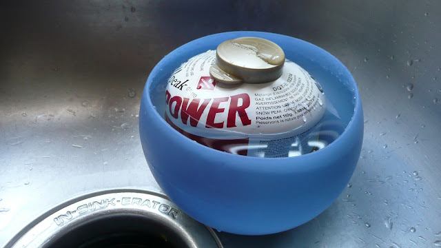
Notice how the “P” in “Power” is just about fully submerged.
To read the rest of the article go here.
This is a great article by Hikin_Jim.
I've often wondered how much was left in the canister.

Ever been there? Herein follows a simple, field practical way to estimate how much gas you have left in your canister:
Before you go out, take a full canister and an empty canister, both the same size and brand. Put the full canister in a container of water. Mark where the water line is.
Notice how the “P” in “Power” is just about fully submerged.
To read the rest of the article go here.
Saturday, July 9, 2011
GPS Setup - Coordinates
What coordinates should you use with your GPS receiver? Latitude and Longitude is fine but check out UTM grid....it's so SIMPLE
![]() I have received a few emails about what coordinate system to use with a GPS?
I have received a few emails about what coordinate system to use with a GPS?
![]()

Coordinate system refers to the geographic grid used on a map; Latitude and Longitude is a coordinate system. The GPS receiver may call it position format.
My recommendation would be to consider:
1. When traveling outside of the United States find out what system the visited country uses. The GPS receiver has coordinate systems pre-loaded for many countries around the world.
a. On a Garmin select “Setup” then select “Units” (below).

Friday, July 8, 2011
A Very Affordable Shelter
Affordable, quick to set up, and waterproof....you can't beat a blue poly tarp.
Leon has a great post here on the poly tarp.Through personal experience I've learned that the 10' x 12' tarp is the best fit in all seasons. The 8' x 10' is just a tad bit too small.
Further, the visibility offered by the tarp his huge. I am finding that the blue tarp stands out in the forest as does hunter orange.
By Leon Pantenburg
My brother Mike and I were on an elk hunt, and had backpacked miles back from any road into Idaho’s Clearwater National Forest.

Because we had to go light, our only shelter was two blue plastic tarps. We looked around quickly, tied a line between two trees that were about 15 feet apart, and quickly set the 10-by-12-foot across it in an A-Frame fashion. We set the tarp so the uphill tree’s drip line would hit it about two feet downhill. We anchored the edges and corners with rocks.
The other tarp was placed inside as a ground cover. The uphill edges were raised with rocks, so water would flow around the sleeping bags, backpacks and rifles that were stacked on it.
TV survival shows to the contrary, it is virtually impossible to make a waterproof shelter out of natural materials, even if you have the time, tools and practice! Even with a tarp, you must have some idea or plan on how to fashion a refuge from the elements.
To read the rest of the article go here.
This emergency tarp shelter is quick to set up and the components are easily-carried. In an emergency, you will probably not have the time and necessary skills to make a waterproof shelter out of native materials.
Because we had to go light, our only shelter was two blue plastic tarps. We looked around quickly, tied a line between two trees that were about 15 feet apart, and quickly set the 10-by-12-foot across it in an A-Frame fashion. We set the tarp so the uphill tree’s drip line would hit it about two feet downhill. We anchored the edges and corners with rocks.
The other tarp was placed inside as a ground cover. The uphill edges were raised with rocks, so water would flow around the sleeping bags, backpacks and rifles that were stacked on it.
TV survival shows to the contrary, it is virtually impossible to make a waterproof shelter out of natural materials, even if you have the time, tools and practice! Even with a tarp, you must have some idea or plan on how to fashion a refuge from the elements.
To read the rest of the article go here.
Thursday, July 7, 2011
Bears
Watch a Polar Bear Hunt
This video 3 minute video is great.
http://www.youtube.com/watch?v=MC26JK9nk-8&feature=player_embedded
This video 3 minute video is great.
http://www.youtube.com/watch?v=MC26JK9nk-8&feature=player_embedded
Accurate Navigation
Just how accurate is your GPS?

The package says that your Global Positioning System (GPS) receiver is accurate to +/- 15 meters and some advertise +/- 3 meters. Just what does that mean to you?
Accuracy depends on several things, most of which are beyond your control. For example, it is reasonable to expect a new GPS with the latest antenna, circuitry, processor capability and memory technology will perform better than one made in 2005. The number of satellites signals a receiver acquires helps too; you’ll need at least four.
The graphic below tells an interesting story.

Through the center of the topographic map, marked with dashed lines is the Pacific Crest Trail (PCT) in Oregon’s Cascades mountain range. Next to the trail is my track log (in red) downloaded from my GPS to my Terrain Navigator software. The track log is my electronic path calculated by the receiver.
I walked on the PCT the entire time. My GPS receiver was in a holster attached to the shoulder straps of my backpack. The receiver’s antenna was exposed but only received data from my front and straight up, my chest blocked signals from behind my back.
As the green of the map indicates I was in a forested area. Tree canopy was moderately thick and may have interfered with signal reception.
To read the rest of the post go here.
Wednesday, July 6, 2011
Stay Cool Durring a Power Outage/Heat Wave Emergency
All things considered, any emergency situation can be made worse by the weather!
My friend Leon has a fine post about heat related casualties.
How will you stay cool when the power goes out during a heat wave?
By Leon Pantenburg
What happens when an earthquake occurs along the New Madrid Seismic Zone (The United States’ second largest earthquake area, located near New Madrid, Mo., along the Mississippi River)? And how much worse will conditions be if this catastrophe happens during the winter when it’s -20 degrees?
On the other hand, how will you stay cool and safe, if an earthquake, flood, tornado, tropical storm etc. knocks out the power grid when the temperature is well over 100 degrees outside? If you don’t have to evacuate, how can you stay cool inside your house without power?
Shift into SurvivalCommonSense.com mode by educating and preparing yourself. To start with: Don’t underestimate the danger of high temperatures!
About 400 Americans die each year from summer heat, according to the Centers for Disease Control and Prevention. Furthermore, the National Weather Service claims excessive heat is the number one weather-related killer, causing more fatalities per year than floods, lightning, tornadoes, hurricanes, winter storms and extreme cold.
To read the complete article go here.