
One feature every outdoorsman should pay attention to is called a “backstop.” A backstop is a boundary or a natural barrier that keeps one in their specified hiking area. If a hiker goes beyond the backstop, then they will know they have gone too far.
When looking over a map of a hiking area, it is essential to understand the impact of terrain and land features. Doing so will allow one to build an association of topography with a general lay of the land. Key on natural and man-made features that includes roads, streams, buttes and buildings. Take the time to really examine the map’s topography by studying the brown contour lines. This attention to detail will give the hiker a “feel” for elevation changes, shape and important land marks. More importantly, it will allow the hiker to develop a mental map of the hiking area. This concept lends itself to map training for those not backcountry experienced, and it is an excellent teaching tool for children.

For example, in the image above ForestRd 32 serves as a backstop. The hiker should remain west of ForestRd 32 because traveling east of 32 is hazardous due to the Swamp. Additionally, note that key terrain features associated with the trail include the river, mountains, a road and the swamp.
The example above is very simplistic but demonstrates the importance of having that “mental map”, especially if visibility becomes an issue.
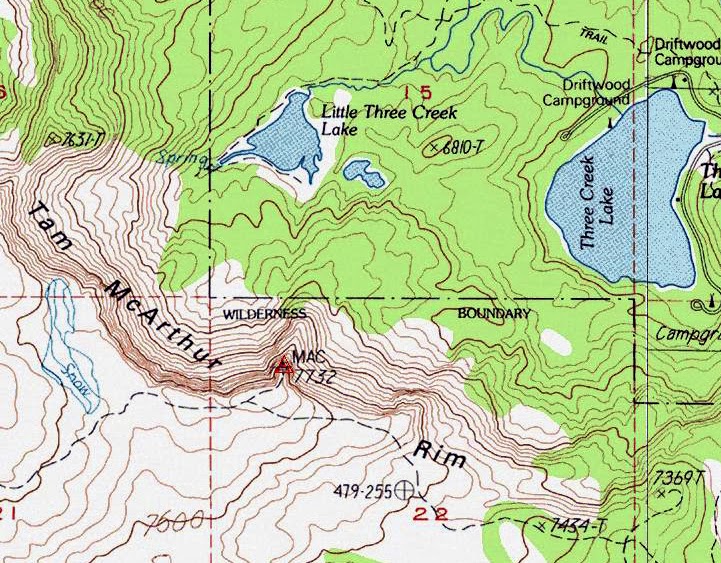
The image above offers another example.
The map above is an area of steep terrain to the west, a lake to the east and trails surrounding most land features. If the hiker planned to bushwack west of the campground (just below the larger lake) and hike in fairly flat terrain with gentle elevation changes, then the steep terrain to the west (Tam McArthur Rim) would be an excellent backstop. This is because it provides confirmation of the hiker’s general location. Care should be taken when using trails that border Little Three Creek lake-note that the trail doesn’t continue west. In such a situation, it is possible for the hiker to walk beyond the lake.
Backstops are another navigation tool that can keep the hiker in a safe location, and should be utilized as a visual resource.
Nice
ReplyDeleteNice bro popular Christmas day quotes for Facebook
ReplyDeleteKeep it up
ReplyDeletewao happy new year 2018 meme
ReplyDelete