Map, Compass & GPS

Map, Compass & GPS
Wild flowers along Fall Creek on the way to the Green Lakes - Oregon

Thursday, July 31, 2014

Dangerous Weather in the Backcountry.

In the field forecasting is an important skill for the backcountry hiker.  Learning the basics is an important first step. 
Let me begin by stating that forecasting begins at home.  Monitor the local news and the cable weather channels to get a broad, general idea of the weather conditions before hitting the trail. 
  
Further refine that information by checking internet sources such as www.wunderground.com and the National Weather Service’s site www.noaa.gov

My “go to” reference is Northwest Mountain Weather by Jeff Renner (published by the Mountaineers.)   Renner is a professional meteorologist and broadcaster, an outdoorsman and flight instructor.  Northwest Mountain Weather provides a superb overview on how “the weather works” in the Pacific Northwest.  Uniquely focused to this region, this book provides an overview on climate and weather, local weather patterns, snow and avalanche conditions, and provides many charts and data sources.  My favorite part of the book is Chapter Seven’s “Field Forecasting Guidelines.” This chapter identifies what to watch for and monitor while in the backcountry.  

The balance of this post will focus on what to consider about hiking during periods of thunderstorm activity.

The dark clouds of a thunderstorm provide a strong sense of mass and energy.  They can be seen a long way off.  Avoid them when possible.  As a storm develops you will notice that the
clouds may change shape, grow taller and darker.
In many cases an anvil shaped cloud growing tall and developing a distinct leading edge maybe observed.  This is a sign that a storm is on the way.

Lightning is the predominant killer associated with a thunderstorm.  Roughly 40 people are killed each year and approximately 240 are injured.  Visit the National Weather Service’s site for more information about lightning safety; http://www.lightningsafety.noaa.gov/medical.htm 
The ideal action to avoid the danger of a significant storm is to get out of the weather.  Leave the field for the safety of a building or a car.  Caves can provide shelter but must be deep and dry.  A shallow cave offers almost no protection.
Renner’s guide lines and actions include:

            “Do watch for cumulus showing strong upward development.
          
            Do choose a campsite uphill from valley floor.
            
            Do get away from exposed areas, pinnacles, peaks.

            Do get away from water.
            Do seek low ground in open valleys and meadows.

            Do move at once if hair or scalp feels tingly.

            Do not stand under trees.”[1]

Wilderness Survival trainer Peter Kummerfeldt amplifies Renner’s comment by adding the following:

            “Be proactive – don’t wait until you are getting wet to suspend outdoor activities.

Don’t be connected to the tallest object in the area. 

If caught outside, move into low trees of even height and stand away from tree trunks.  Stay away from isolated trees.

Water is a great conductor of electricity – get out of the water at the first sign of a storm developing.”[2]  (For more information visit Kummerfeldt’s web site, www.outdoorsafe.com.)

Thunderstorms have the potential to deliver large quantities of water.  Look for higher ground and stay out of stream beds that may flood significantly and without warning.

I monitor my GPS receiver’s barometer.  I change my elevation plot to a pressure plot and leave the receiver on.  Even though a GPS receiver may not be the most accurate it is the plot’s trend over time that I am concerned about.  Should I see the pressure drop noticeably I’ll take shelter or return to my vehicle.

The key is to stay alert and make a plan of action when a storm approaches.  

I previously posted a short article about using your GPS to monitor barometric pressure while in the backcountry; go here to read the post. 


[1] Jeff Renner, Northwest Mountain Weather, (The Mountaineers, 1992), p 100
[2] Peter Kummerfeldt, Surviving a Wilderness Emergency, (OutdoorSafe Press, 2006), p56-57

Wednesday, July 30, 2014

Planning Your Overnight Backcountry Trip

The following post is by Sierra Shafer at Seattle BackpackersMagazine.com. 

by
              
One: Choose your team. If this is your first time on an overnight backcountry trip, it is important to consider with whom you will be experiencing this. While overnight in the backcountry can be some of the most fun you’ll have exploring the wilderness, the experience can often test your temperament and your ability to react to unpredictable circumstances. It can be beneficial to go with someone who is more experienced. They can share their knowledge from being in the field. However, keep in mind that in the backcountry, you are responsible for your own safety and well-being. Be careful not to rely too heavily on your partner. If you aren’t the only newbie in the group, great! You can all experience a wonderful first together. Whether you travel with a group of first timers or a seasoned pack of pros, the key is to communicate early and often about each member’s expectations and responsibilities

To read the rest of Sierra's post go here.

Tuesday, July 29, 2014

Camp Stove Safety

Carbon Monoxide is  a killer.  Do you even consider this danger when cooking in camp?  The following post came from the UK and it's worth your consideration.

by Jon]

This week's Monday Tip is a timely summer camping one - beware the dangers of carbon monoxide poisoning when you're cooking under canvas this summer, not just from gas stoves, but also from less obvious sources like portable barbecues and even gas-powered fridges.

Carbon monoxide poisoning is particularly dangerous because the gas, produced as a by-product of stoves and other gas-powered appliances is colorless, odorless and poisonous. Symptoms include headaches, drowsiness, dizziness, chest pains, nausea and vomiting.

To read the rest of Jon's post go here.  safety 

Sunday, July 27, 2014

Walking A Line Of Bearing

A short discussion of plotting a line of bearing on a map, determining the direction to a destination and then walking a line of bearing.

Before technology entered the backcountry world of the outdoors, the primary and proven tools of navigation were a map and compass.  Compass navigation remains an important component of the “Ten Essentials” for wilderness travel.  Knowledge of how to use map and compass takes education and practice.  Further, such knowledge will enhance GPS navigation as many concepts are interchangeable.
This article will discuss one of the basic uses of a compass, how to adjust the compass to walk a specific direction to get to a destination; to get from point A to point B.
Let’s start with a review of the key features and parts of a compass; see Figure 1 below.  This figure is an example of a standard baseplate compass found in most outdoor stores.  I recommend the backcountry navigator use a declination adjustable compass such as the Brunton 8010G or the Silva Ranger 515CL.

Figure 1
  • The red magnetic needle rotates freely and points to magnetic north.  Remember that metal objects such as belt buckles, watchbands, rifle barrels and car bodies will deflect the needle.  Battery powered electronics will cause the needle to deflect too.
  • The “direction of travel arrow” points in the direction of intended travel.  Always point the direction of travel arrow away from you; perpendicular to your body.
To read the complete post go here.

Saturday, July 26, 2014

Reaching Out for Search and Rescue


I listened to John Kruse’s fine outdoor radio program this morning.  One of the guests was the Sheriff from Grant County in Oregon.  His interview centered on Search and Rescue (SAR) in a small rural county.  To listen to the interview go here https://www.youtube.com/watch?v=hWFOdd6tQns

I would like to add to the Sheriff’s recommendations about what the hiker should do about proper preparation before heading into the backcountry.   Carrying the ten essential systems is important; no doubt about it.

I have added an essential item to my list – communications. Consider how you are going to communicate to SAR.  Getting SAR activated is not magic but it does take time to get the volunteers alerted and moving to the subject.

My first recommendation is to take a look at your cell phone.  If you are holding out on getting a new phone reconsider; now.  New cell phones have what is called the E-911 chip that activates when 911 is dialed.  This activation sends the hiker’s position coordinates to the 911 dispatch center based on the phones GPS system; the accuracy is reasonable.   The E-911 chip has helped to eliminate the hours of searching and allows SAR volunteers to go straight to the subject.   Older phones and some carriers my not have this capability.  Check with the cell service provider and take another look if you use those cheap phones (e.g., Tracfone) sold at the box stores.  Remember, this requires the cell phone to have connectivity with a cell tower.

Emergency dispatch call centers may have the option to ping your phone.  This is essentially triangulating the hiker’s position using a combination of the cell phones signal and the cell towers.  Multiple towers are best.  Critical to accurate locating ability is the number of towers in the hiker’s area.  For example, Oregon’s Mount Hood has a lot of cell towers in the county adjacent to the mountain and surrounding forests.  Multiple towers with the latest modifications provide accurate locating data.  On the other hand, the ski resort at Mt. Bachelor, Oregon has only one tower thus the position data is always suspect for those hiking on the Pacific Crest Trail west of that particular mountain.

Another option is to carry one of the locating beacons such as the SPOT by Global
Telecommunications.  A SPOT beacon retails for around $100 and requires an annual subscription service that costs about $100.  This technology is evolving quickly, is satellite based and has been critical to finding lost and injured hikers every year.  Take the time to search this carefully so that it matches your requirements.  Visit www.gpstracklog.com to find product reviews and sources.

While electronics are wonderful consider carrying a signal mirror and a quality whistle.  Though relatively inexpensive these two components are key to finding lost hikers each year.

Thursday, July 24, 2014

A Solar Storm That Almost Hit Earth

The following post is an article from the Washington Post.  A coronal mass ejection would have serious and significant impact on society.
  

How a solar storm two years ago nearly caused a catastrophe on Earth

Solar flare preceding CMEs on July 22, 2012 (NASA)
CME captured by NASA July 23, 2012 (NASA)

On July 23, 2012, the sun unleashed two massive clouds of plasma that barely missed a catastrophic encounter with the Earth’s atmosphere.  These plasma clouds, known as coronal mass ejections (CMEs), comprised a solar storm thought to be the most powerful in at least 150 years.

“If it had hit, we would still be picking up the pieces,” physicist Daniel Baker of the University of Colorado tells NASA.

To read the rest of the post go here.

Wednesday, July 23, 2014

Rain Suit or Poncho

Interesting discussion from my friend Leon's blog. 

by Leon Pantenburg

Rain follows me. Over Christmas break, 1977,  John Nerness and I went backpacking in Death Valley, CA. Packing rain gear seemed like a waste of time – after all, the average annual rainfall is 2.36 inches.

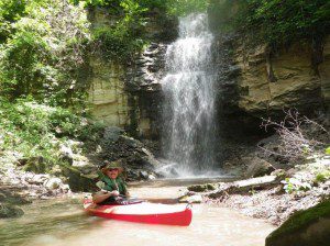
Bob Patterson at waterfall on Blue Earth River, Minnesota.
Bob Patterson kayaking at a waterfall on the Blue Earth River, Minnesota. (Bob Patterson Photos)

But two days before Christmas, we ended up at the bar at Furnace Creek, waiting out a rain storm that washed out the road.

On my John Muir Trail through hike, it rained nine consecutive nights, with intermittent showers during the day. In Louisiana, during my 1980 Mississippi River canoe voyage, the rain lasted more than 40 hours at one stretch.

The moral of the story is you never truly know what the weather might hold and it’s always best to prepare for anything. And you better prepare for the worst!

To read the rest of Leon's post go here.

Tuesday, July 22, 2014

A Compass Tune-up

 
Recently I watched on one of the many outdoor cable shows.  The guest is a noted ballistics expert, writer and occasional backcountry guide.  During a segment of the interview he was demonstrating what was in his day pack.  It kept my interest, had the ten essentials, and all was going just fine until he brought out his compass.  It looked like a wonderful antique, might have come across the Great Plains and Rockies with Lewis and Clark –but in terms of reliability-it was questionable. The sad part is he spent absolutely no time discussing the key factors of having a reliable compass.  He touched his compass and quickly put it down. 
 
And touching a compass is about all that most people do too.  Hunters preparing to go afield will spend hours with their rifle at the range evaluating their zero, adjusting optics, and measuring the initial velocity of that hot new round.  Navigation takes time to get dialed in too.
 
Navigation is not “rocket science” but it takes practice.  It is a perishable skill.  The analogy that I use in my wilderness navigation classes is that you can hop on a bike after not riding one for ten years and head on down the road.  But trying to triangulate after ten months can be a chore.
 
For starters, you need a decent compass.  Leave the $5.00 compass on the shelf at the store.  For more information on buying a compass check out my article on selecting a compass.
 
Here are a few recommendations for a compass tune up:
 
·     Store your compass in a safe spot.  Keep the compass off the dash of the rig, away from flashlights and the GPS.  Let’s not take a chance that an electrically induced magnetic field will degrade your compass.
 
·     Compare your compass with another to verify that the red needle is pointing to magnetic north.   Take it a step further and find a road in town that is aligned north/south.   Most likely it will be aligned in degrees true; as in true north.  Again, verify that the compass is pointing correctly.  Do this for every compass you own.
 
·     Is the compass leaking?  Is there an air bubble floating in the compass housing?  I “deep six” (toss) those units.
 
·     Brush up on your compass navigation skills.   June Fleming’s book “Staying Found” is a excellent read.   Visit www.landnavigation.org.  Practice shooting a bearing, triangulating your position and orienting your map and compass to your surroundings.
 
·     Review the components of a Topographic map.  Start with the USGS’ site here.
 
·     Insure you have the compass adjusted to the correct declination.
 
·     Practice with your children.  Give them a good education with a map and compass before you give them a GPS.
 
·     Don’t depend on your friends being the navigation experts.  Make it a goal to exceed their skills.  You might find that your initial impression was mistaken. Instead of a “sense of direction” develop the skill of navigation.
 
Practice with a compass is essential to safe wilderness travel.  To quote Fleming, “The key to knowing where you are is constant awareness.”


Thursday, July 17, 2014

Lost in the High Sierras

Another lost hiker.  From the Merced Sun-Star

by Carmen George

Hiking from the summit of a remote peak in Sequoia and Kings Canyon National Parks last Saturday, something went very wrong for Gregory Hein of Clovis.

Climbing down the rocky mountainside of Mount Goddard — which soars to a height of about 13,500 feet — rocks loosened beneath the 33-year-old's feet.

As he tumbled down, a large boulder plowed into his leg — breaking it in a serious compound fracture — and he fell from a ledge.

Then things got even worse.

Read more here: http://www.mercedsunstar.com/2014/07/11/3744303/clovis-hikers-harrowing-ordeal.html#storylink=cpy

Tough guy, no doubt about that.  From a SAR perspective I do appreciate the last few paragraphs of the  post:

Charlton said he was "incredibly surprised" to hear Hein was missing and applauded him for good wilderness sense in a difficult situation: Finding water and shelter, and staying "put" — waiting for a response.

Still, McCormick of the Fresno County sheriff's search and rescue unit said Hein could have done a few things differently.

When going on a long backpack, consider carrying a satellite-linked device that sends messages about your location, which rescuers can access, he said. Before entering the backcountry, always apply for a wilderness permit so there is documentation of your proposed route, and never hike alone, McCormick said.

Read more here: http://www.mercedsunstar.com/2014/07/11/3744303/clovis-hikers-harrowing-ordeal.html#storylink=cpy

To read the complete post go here.

Wednesday, July 16, 2014

The 10 Essentials - What You Don't Need to Carry

I came across this post from the Appalachian Mountain Club's web site.  The writer discusses why you really don't need to carry a compass.

The post starts out by stating:

The Least Useful Item in the Ten Essentials?
I recently wrote about the Ten Essentials,
which includes quite a few extremely, ahem, essential items. But which is the least useful? From my perspective, it's the one I've carried for more than 20 years and barely ever used: a compass.
Why do you need a compass?
A compass allows you to very quickly orient yourself if you become turned around in dense off-trail woods; during low-visibility, fogged-in conditions; or for other reasons.
 
To read the rest of the post go here
 
Well let's think about this. 
 
A compass weighs next to nothing.  It takes up little space.  It's vital when you need it.  Sure you can use terrain association and good map skills to fix you position when on the trail. 
 
Take a look at some of the comments that follow the post.

Tuesday, July 15, 2014

REI Web Page

Here is a web page that every one should keep an eye on.

It's REI's list of coupons and promotions.

Go here to check this one out.

Thursday, July 10, 2014

Compass Accuracy

Check out my latest post on sectionhiker.com about compass accuracy


The quality of a compass wil make a difference in its accuracy
The quality of a compass will make a difference in its accuracy
Navigation is a practiced skill, and when not practiced on a regular basis it becomes easily forgotten. Sighting and triangulating with a magnetic compass is a skill that the responsible outdoorsman should never allow to lapse.
The accuracy of a magnetic compass and the information presented depends on land characteristics, the quality of the compass and the ability and knowledge of the hiker.
The hiker will experience natural factors and conditions in the backcountry that impact accuracy. Some of these factors the hiker will have no control over but may be able to mitigate. One of the most important factors is declination. Declination is the angular difference between true north and magnetic north.
To read the post go here.

Wednesday, July 9, 2014

Ranger Bands


An Elastic, Durable Addition to a Hiker’s Tool Kit

I’ve added these ultralight utility bands, called ranger bands, to my kit along with a compact multi-tool (e.g., a Leatherman tool), a few yards of duct tape and 50 feet of parachute cord.
Ranger bands are small sections of bike inner tube that are individually cut across the tube itself. The tube cuts quickly and cleanly with a common pair of household scissors. These bands are a larger homemade variant of the common rubber band. Strong and versatile, they are handy and straight forward to use. They can be cut in various sizes and lengths and band diameters will range from that of a touring bike inner tube to that of a motor cycle. Possibilities abound.

To read the rest of the post go here.


Ultralight_Ranger_Bands